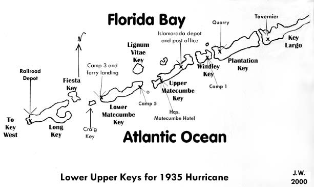
History of the Upper Keys
The Bridge That Never Was
By Jerry Wilkinson
(Slow downloading - 22 images)
Each year
millions of people pass
the Florida Keys Memorial in Islamorada at MM 81.5 without realizing
that
part of its tribute is to the World War One veterans who died in the
Keys
building a bridge.  As
easily seen are the innocent looking coffin-like rectangles in the bay
just south of Lower Matecumbe Key at about MM 73.1 that are the piers
for
this bridge that never was. These chunks of concrete are the actual
monuments
for this little know epic struggle of politics and human survival. For
years a small portion of the earthen approach that survived the 1935
Hurricane was used to store lobster traps in the off season. As
easily seen are the innocent looking coffin-like rectangles in the bay
just south of Lower Matecumbe Key at about MM 73.1 that are the piers
for
this bridge that never was. These chunks of concrete are the actual
monuments
for this little know epic struggle of politics and human survival. For
years a small portion of the earthen approach that survived the 1935
Hurricane was used to store lobster traps in the off season.
This history
evolved from the Great
Depression, the Roosevelt New Deal program, the Federal/Florida
Emergency
Relief Administration, Florida State Road Department and many other
socio-politico-economic
elements. The reader is asked to wade through the introductory portions
to arrive at the actual attempt to build the elusive bridge. Extensive
use of images is used in hope that each image will supplant a thousand
words as well as none of these artifacts exist today except the eight
bridge
piers and an island that represents a portion of the bridge approach
that
were under construction on September 2, 1935 at MM 73, bayside. Please
chick on any image to enlarge.
- Bonus for War
Veterans -
Government assistance for
war veterans goes
back to March 25, 1588 when England established compensation for
veterans
after its war with Spain. In the American Colonies, the 32nd Article of
the General Assembly of Virginia in 1624 passed a body of laws aimed at
paying benefits to soldiers injured during the Indian War. In 1636, the
Plymouth Colony followed with the first provisions for service
connected
disabilities. The Continental Congress in 1776 provided for a pension
and
later in March 1818, a limited service pension was added. A more
liberal
law was passed in 1832 and benefits extended to the widows in 1836. All
of these efforts were aimed at the disabled veteran.
- World War One Veterans -
After World War 1,
Congress in
1924 approved an Adjusted Compensation Certificate, also known as the
"Soldier's
Bonus" to be paid veterans in 1945 or upon death. When the time came,
each
veteran was to receive $1 for everyday served at home and $1.25 for
days
served overseas.
The great depression came on in the
late 1920's
and times were hard throughout the country. As the depression years
passed
one by one, Representative Wright Patman of Texas introduced a bill
calling
for the immediate payment of the Soldier's Bonus. Many veterans with
their
pride, savings and credit exhausted, began considering that a few
dollars
while alive would be more useful than when dead in 1945. To effect
passage
of the Patman bill, a few hundred jobless veterans from Oregon began a
"Bonus March" across the country to Washington, D.C. As the saying
goes,
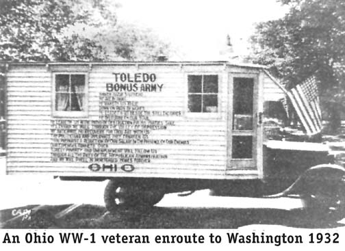
it snowballed. By June 1932 there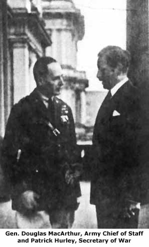 were an estimated 20,000 jobless and homeless veterans in the Capitol's
vicinity. They became known as "Bonus Expeditionary Force" or "Bonus
Army."
were an estimated 20,000 jobless and homeless veterans in the Capitol's
vicinity. They became known as "Bonus Expeditionary Force" or "Bonus
Army."
The bill passed
easily in the
anti-administration House and it was sent to the Senate for certain
defeat
and on June 17, 1932 it was defeated 62 to 18. Still more veterans were
arriving in Washington than departing and being election year, Congress
wanted to adjourn to get on with electing a President.
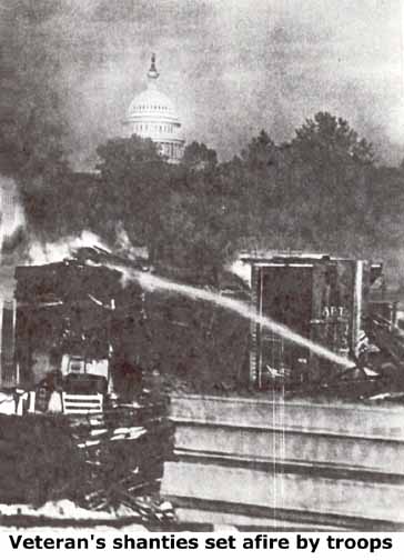
It is a long story,
but in
the end General MacArthur routed the helpless veterans with tanks, tear
gas and burned their makeshift camps. The public sympathy was with the
veterans and some say this incident gave Franklin D. Roosevelt an
easier
victory over President Hoover.
The annual trek to
Washington
became am annual pilgrimage for WW-1 veterans in the forthcoming years.
-
-
 - Overseas
Highway Project
-
Meanwhile,
what does this
have to do with the Florida Keys? In 1912 rail service was opened from
the mainland to Key West. In 1928 vehicle service was provided but with
two water gaps spanning 40 miles in the center. The water gaps
were
serviced by three ferryboats. This highway system was called State Road
4-A. The ferry service was barely adequate being slow, limited
capacity,
unreliable, inconvenient and relatively expensive for the time.
Consulting
Army Engineers estimated the cost to be from $7.5 million for a poor
highway
to $13.7 million for a first-class continuous highway.
- Overseas
Highway Project
-
Meanwhile,
what does this
have to do with the Florida Keys? In 1912 rail service was opened from
the mainland to Key West. In 1928 vehicle service was provided but with
two water gaps spanning 40 miles in the center. The water gaps
were
serviced by three ferryboats. This highway system was called State Road
4-A. The ferry service was barely adequate being slow, limited
capacity,
unreliable, inconvenient and relatively expensive for the time.
Consulting
Army Engineers estimated the cost to be from $7.5 million for a poor
highway
to $13.7 million for a first-class continuous highway.
In October of 1932,
the Reconstruction
Finance Corporation (RFC) forwarded a plan to Congress for a $10.7
million
load to be amortized over 20 years repaid with toll fees. It fell on
deaf
ears as the Great Depression was on and even $1 million was out of the
question.
After
Franklin Roosevelt
became president and as part of his New Deal economic program, the
Federal
Emergency Relief Administration (FERA) was created on May 22, 1933 with
Harry Hopkins as its head. Congress authorized $500 million for which
to
operate, of which one half was for matching grants and one half as
discretionary
funds. The Federal Emergency Relief Administration was the second phase
and emphasized public construction.
Among other things,
FDR also
had the residuals of the Bonus Army to contend with. The veterans were
persistent, but only about 3,000 showed up in Washington in March 1933
and only 1,500 in May 1934.
To provide
employment for the
Bonus Army and other WW-I veterans, a project was created to renovate
Fort
Jefferson in the Dry Tortugas. However, Fort Jefferson was owned by the
Military and needed to be transferred to the Department of Interior as
a national park to justify use of FERA funds. The administration was
aware
of Monroe County's need for an improved through highway and with the
transfer
of Fort Jefferson at a snail's pace, the use of the WW-1 veterans was
diverted
to the highway project. The foregoing is a simplification, but is how
the
project was authorized.
-
- Monroe County -
-
Leaving the
veterans for a moment,
newspapers throughout the south announced in the first week of July,
1934
that "KEY WEST AND MONROE COUNTY SEEK RECEIVERSHIP - Both Thrown Into
State
of Emergency by Economic Trouble - 75 Percent of People Jobless."
Further
in the article was a partial explanation, "Accessible from the mainland
only by train, ferry, or airplane, Key West long has sought a vehicle
bridge
stretching across the keys, only to meet rebuff at every turn. Within
the
last six months, the Public Works Administration refused to make a loan
for the bridge, on the grounds it would not be self-supporting." The
state
was in no financial position to bail out Monroe County. The dream of a
continuous highway was over for now unless another source of funding
could
be found and it appears that the jobless veterans in Washington were
the
solution.
-
- Federal Emergency Relief
Administration -
-
Each state had a
FERA administrator
and in Florida it was Julius Stone. Julius Stone liked Key West and had
an almost immediate solution for Key West - tourism. He
envisioned
Key West as The Bermuda or The Gibraltar of Florida, the name depending
on which newspaper one read, but a better transportation system would
be
necessary.
The story is that
another cost
survey was made to replace only the water gaps with a highway similar
to
the railroad but wider at an estimated cost of $2 million. A
bridge
would be built from Lower Matecumbe Key to Long Key (the subject of
this
page), a highway across Long Key with a bridge to Grassy Key and a
bridge
from Knight's Key via Pigeon Key to No Name Key. Most of State Road 4-A
had already been completed to connect it 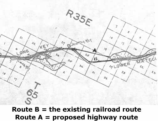 to
these bridges when built. Construction would begin in the Upper Keys
shown
as "Route A" on the map at the right. Just how the funding for the
bridging
of the water gaps was handled is not clear. The author believes it more
or less evolved between the FERA's interest in providing employment for
the veterans and the state/county's interest of building a through
highway.
In June 1935 Julius Stone moved to the Works Progress Administration
(WPA).
- to
these bridges when built. Construction would begin in the Upper Keys
shown
as "Route A" on the map at the right. Just how the funding for the
bridging
of the water gaps was handled is not clear. The author believes it more
or less evolved between the FERA's interest in providing employment for
the veterans and the state/county's interest of building a through
highway.
In June 1935 Julius Stone moved to the Works Progress Administration
(WPA).
-
- State Road Department -
-
The highway project
had two lines
of supervision.  The
engineering and construction was under the supervision of B. M. Duncan,
Consulting Engineer for the Florida State Road Department. The labor
force
was the responsibility of FERA's director of Veterans Work Program,
Fred
B. Ghent.
- The
engineering and construction was under the supervision of B. M. Duncan,
Consulting Engineer for the Florida State Road Department. The labor
force
was the responsibility of FERA's director of Veterans Work Program,
Fred
B. Ghent.
-
- World War I Veterans -
-
Therefore, there were thousands
of veterans
seeking employment and a fully funded FERA with bridges to build. When
the decision was made to take the veterans from Fort Jefferson and
devote
them to a Monroe County highway enhancement work began rather fast. The
saga unfolds as told by the Homestead Leader Enterprise on
November
16, 1934, "ENGINEERS BUSY LAYING OUT WORK FOR 300 VETERANS ON OVERSEAS
HIGHWAY BRIDGES -- FERA Project Would Close Matecumbe-Marathon Gap --
Links
Up With Key West Relief Work -- Advance Detail Builds Camp Then Joined
by Main Body."
The Miami Daily News
had announced
on October 19, 1934 Mr. Stone's proposed "Overseas Gap To Be Filled"
without
revealing the labor source.
-
- Veteran's Work Camps -
-
In Florida,
FERA created
a total of eleven Veteran's Camps, a cross between relief camps and
Civilian
Conservation Camps (CCC), three of them in the Keys. This crossbreed of
veteran's rehab camp and the CCC camp along with the dual
responsibilities
of FERA and the SRD caused considerable confusion from then on. The
CCC's
wore a uniform, took a physical exam for entrance and were structured
as
a military organization. The veterans often conducted themselves along
military lines using military terms, but were organized as civilian
organization.
Each camp had a superintendent, but was often referred to as the
commander
or captain.
The veterans
sent to
the Keys were probably a cross section of American citizens. Some were
well educated, some were professional athletes and some were
tradesmen.
Some were poison gas victims, some were shell-shock victims, some were
simply wounded and some had no incapacitation what-so-ever. Some had
brought
their families with them and worked two jobs to make ends meet. They
were
in new make shift camps with little recreational activities in a
sparsely
populated area. The 1935 census showed the population of the entire
Upper
Keys as 673. The only structures on Lower Matecumbe were the Terminal
Lunch
serving the ferry landing and the Corslan Fish Company with
headquarters
in Miami.
In the beginning and almost
throughout the project's existence, construction of the work camps was
first and foremost, especially for FERA. Camp 1 on upper Windley Key
was
the first camp constructed, presumably because of quarrying the coral
rock
on Plantation Key. Camp 3 on the lower end of Lower Matecumbe Key was
the
second Keys' camp and the one from which the highway would proceed
from.
Additional personnel housing was needed and Camp 5 was built on the
upper
end of Lower Matecumbe Key. See the map provided. The Matecumbe Hotel
was
leased from Captain Ed Butters as the FERA headquarters. Captain
Butters
kept the restaurant portion of the hotel.
-
- Plantation Key Quarry -
-
 The
Plantation Key quarry across highway US-1 from the present Florida
state weigh station (2001) was a typical strip mining quarry for blocks
and crushed rock. A series of three images are provided. The site
purpose
was to provide crushed rock fill and rectangular coral blocks to be
placed
inside the bridge piers to eliminate the necessity for huge amounts of
concrete. All images may be enlarged by clicking on the image. In photo
number 1 the rotary trencher machine cut trenches to provide the
crushed
rock and spaced each trench the correct distance for rectangular blocks
of coral to be removed. The
Plantation Key quarry across highway US-1 from the present Florida
state weigh station (2001) was a typical strip mining quarry for blocks
and crushed rock. A series of three images are provided. The site
purpose
was to provide crushed rock fill and rectangular coral blocks to be
placed
inside the bridge piers to eliminate the necessity for huge amounts of
concrete. All images may be enlarged by clicking on the image. In photo
number 1 the rotary trencher machine cut trenches to provide the
crushed
rock and spaced each trench the correct distance for rectangular blocks
of coral to be removed.
-
Quarry photo number 2 provides
and overall 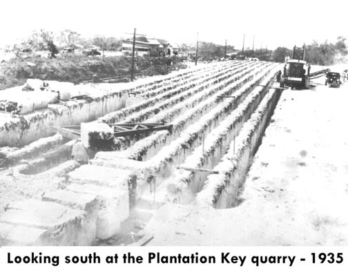 perspective
with the trencher to the right, rows of potential blocks in the center,
blocks being removed at the lower center and removed blocks at the
lower
left. The personnel lived at Camp 1 across Snake Creek on Windley Key.
The quarry was located just northeast of the entrance to the Venetian
Shores
subdivision. Today's subdivision entrance would be at the far end of
this
scene. perspective
with the trencher to the right, rows of potential blocks in the center,
blocks being removed at the lower center and removed blocks at the
lower
left. The personnel lived at Camp 1 across Snake Creek on Windley Key.
The quarry was located just northeast of the entrance to the Venetian
Shores
subdivision. Today's subdivision entrance would be at the far end of
this
scene.
-
-
-
Quarry photo number 3 shows
a crane loading  the
coral blocks onto railroad flat cars to be transported to Camp 3 on
Lower
Matecumbe for use in the bridge piers. No one is certain how the
rectangular
blocks were loosened at the bottom, but many suggest very low powered
dynamite
charges. The blocks appear to in good condition with little sign of
fracturing.
Flagler filled his bridge piers with concrete, but FERA put many of
these
blocks inside of each pier's form.
- the
coral blocks onto railroad flat cars to be transported to Camp 3 on
Lower
Matecumbe for use in the bridge piers. No one is certain how the
rectangular
blocks were loosened at the bottom, but many suggest very low powered
dynamite
charges. The blocks appear to in good condition with little sign of
fracturing.
Flagler filled his bridge piers with concrete, but FERA put many of
these
blocks inside of each pier's form.
-
-
-
- Camp 3 Construction -
-
Camp three was
adjacent to the
Corslan Fish Company and vehicle ferry dock on lower Lower Matecumbe
Key
at Mile Marker 73.5' This was where the 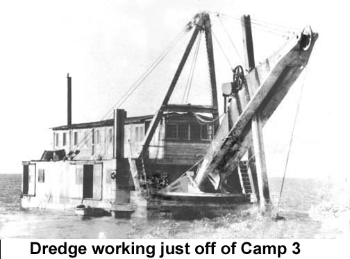 actual bridgework was to be done. Camp 1 was for quarrying rock
and
Camp 5 was just for housing (there were fewer mosquitoes there). About
half of the workers were at Camp 3 and the other half were housed
at Camp 5 on the northern end of the Key. Another series of four photos
provides a brief history of Camp 3. Photo 1 is the dredge that
excavated the docks for the workboats and materials, the
area
for the piers to be constructed and for the bridge approach out to
where
the concrete arch bridge would begin.
actual bridgework was to be done. Camp 1 was for quarrying rock
and
Camp 5 was just for housing (there were fewer mosquitoes there). About
half of the workers were at Camp 3 and the other half were housed
at Camp 5 on the northern end of the Key. Another series of four photos
provides a brief history of Camp 3. Photo 1 is the dredge that
excavated the docks for the workboats and materials, the
area
for the piers to be constructed and for the bridge approach out to
where
the concrete arch bridge would begin.
-
-
-
Camp construction photo number 2
shows the clearing 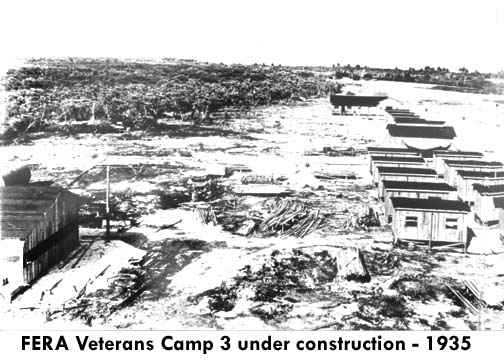 and
the beginning of the construction of the permanent four-man living
structures.
Since Camp 3 was the primary bridge construction site, it would
maintain
and house a significant amount of construction equipment. Most
sub-contractors
were based here. and
the beginning of the construction of the permanent four-man living
structures.
Since Camp 3 was the primary bridge construction site, it would
maintain
and house a significant amount of construction equipment. Most
sub-contractors
were based here.
-
-
-
-
-
-
-
Camp Construction photo number
3 is more
or less how 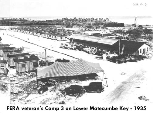 the
living portions of Camp three appeared in 1935. The railroad passes
across
the top portion and that could be a locomotive to the left of the water
tower. The water tower for the desalination plant can be seen in the
upper
right. The motor pool at the center right is well stocked with
vehicles.
New living quarters are being built to the left. Tents are still being
used as temporary shelter and storage. the
living portions of Camp three appeared in 1935. The railroad passes
across
the top portion and that could be a locomotive to the left of the water
tower. The water tower for the desalination plant can be seen in the
upper
right. The motor pool at the center right is well stocked with
vehicles.
New living quarters are being built to the left. Tents are still being
used as temporary shelter and storage.
-
-
-
-
Camp construction photo number
4 shows the Camp 3 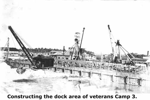 dock
area almost completed. Notice the huge pieces of sub-contractor
equipment
being used. This emphasizes that the complex bridge construction was
handled
by sub-contractors hired by the State Road Department. These were under
the direction of E. H. Sheeran who also had worked for the Florida East
Railway construction bridges from 1905 to 1912.
- dock
area almost completed. Notice the huge pieces of sub-contractor
equipment
being used. This emphasizes that the complex bridge construction was
handled
by sub-contractors hired by the State Road Department. These were under
the direction of E. H. Sheeran who also had worked for the Florida East
Railway construction bridges from 1905 to 1912.
-
-
-
-
- Bridge Construction -
-
After much
preparatory documentation we are ready to begin construction of the highway bridge. In photo number
1 and early in the project, Camp 3 can be seen in the background.
Wooden
piles have been driven to form and support the placing of a steel
cofferdam
much like the work done on the Bahia Honda railroad bridge. These were
to be the first concrete arches and a filled approach will be dredged
and
built in the shallow water to connect Lower Matecumbe Key out to the
concrete
arches.
are ready to begin construction of the highway bridge. In photo number
1 and early in the project, Camp 3 can be seen in the background.
Wooden
piles have been driven to form and support the placing of a steel
cofferdam
much like the work done on the Bahia Honda railroad bridge. These were
to be the first concrete arches and a filled approach will be dredged
and
built in the shallow water to connect Lower Matecumbe Key out to the
concrete
arches.
This series of concrete arches were
the first
of the project and the completed bridge was to go straight to Fiesta
Key
(known then as Jewfish Bush Key), which is a few thousand feet shorter
than following the railroad route via Craig Key. From Fiesta key
the bridge would be along side of the railroad bridge to Long Key.
-
-
-
The interlocking steel
cofferdam  is
shown completed and slabs of Plantation Key quarry coral rock are
placed
inside spaced so that when concrete is poured they will be encased with
concrete. No steel rebar is visible and none was probably used. The
railroad
discontinued the use of steel rebar after construction of the Long Key
bridge. Remember, this is the pier to support the concrete arches
when set on top. The stress is vertical and downward and vehicles will
not weigh as much as trains. is
shown completed and slabs of Plantation Key quarry coral rock are
placed
inside spaced so that when concrete is poured they will be encased with
concrete. No steel rebar is visible and none was probably used. The
railroad
discontinued the use of steel rebar after construction of the Long Key
bridge. Remember, this is the pier to support the concrete arches
when set on top. The stress is vertical and downward and vehicles will
not weigh as much as trains.
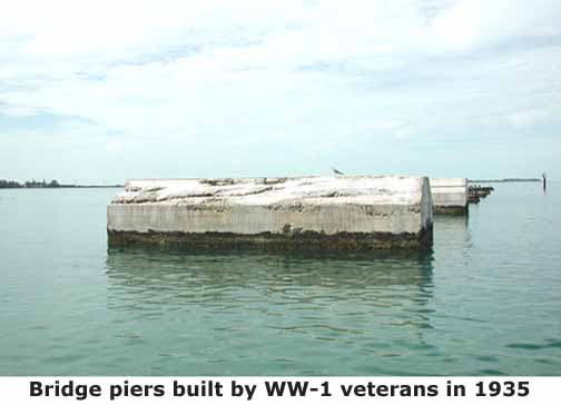
When the coffers
were removed
the piers were about 10 feet by 30 feet. At an average tide a completed
pier stands about seven feet out of the water. The average water depth
around the piers is about 10 feet deep; therefore, the total height is
about 17 feet.
-
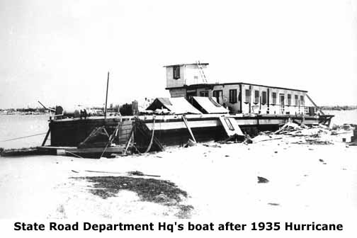
- The Labor Day Hurricane of 1935 -
-
Work on the bridge piers
was progressing
reasonably fast when the great "Labor Day" hurricane of 1935 was
declared
a tropical disturbance in the Caribbean headed westward on Thursday,
August
29. It was forecasted to be 275 miles east of Havana with probably
hurricane
force winds. On Sunday at 4:00 P.M., the advisory placed it 200 miles
east
of Havana moving slowly westward and again at 10:00 A.M. Monday,
September
2. The 4:30 P.M. advisory reported, "Tropical storm now apparently
moving
northwestward toward the Florida Keys accompanied by hurricane winds
over
a small area." It struck the Upper Keys only four and a half hours
later.
Untold numbers of veterans and civilians perished. The Official figure
then was 164 civilians and 259 veterans, however the actual number
varied.
Local, state, railroad, Presidential and Congressional investigations
followed.
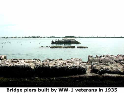
It is not clear whether these
bridge piers 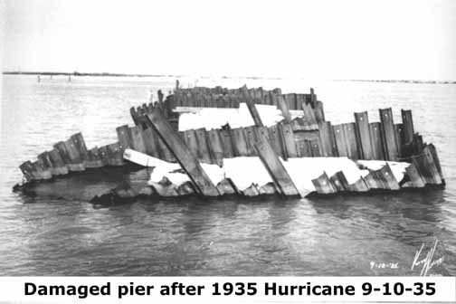 were
some in progress of being built or the ones that remained; however, the
author is convinced that they are the ones we see today with the steel
coffer material rusted away. The water around the uncompleted piers,
especially
the last pier, is cluttered with pieces of this steel coffer
material.
Eight piers remain above the water line today and there may have been
the
ninth one started at the southwest end of the group. The last pier
above
water has significant pieces of rusted steel coffer material folded
away
from the pier. It should be remembered normal rusting in salt water,
category-4
Hurricane Donna in 1960 and category-3 Hurricane Betsy in 1965 have
contributed
to the disappearance of the steel material. There is no evidence of
steel
rebar in any of the piers. were
some in progress of being built or the ones that remained; however, the
author is convinced that they are the ones we see today with the steel
coffer material rusted away. The water around the uncompleted piers,
especially
the last pier, is cluttered with pieces of this steel coffer
material.
Eight piers remain above the water line today and there may have been
the
ninth one started at the southwest end of the group. The last pier
above
water has significant pieces of rusted steel coffer material folded
away
from the pier. It should be remembered normal rusting in salt water,
category-4
Hurricane Donna in 1960 and category-3 Hurricane Betsy in 1965 have
contributed
to the disappearance of the steel material. There is no evidence of
steel
rebar in any of the piers.
-

The fill in the foreground now
appears
as an island, some call it Veteran's Key, between the eight bridge
piers
and Lower Matecumbe Key. As with most of the bridges in the Keys, the
water
was shallow in the immediate area close to the Key and filled
approaches
were extended out to the beginning of the bridges. Filled approaches
were
much cheaper and less technical to build than bridges.
Hurricanes have
washed out
and eroded the once bridge approach between the remaining island now
privately
owned and Lower Matecumbe Key. Some of this fill between the Key and
the
island was also used for the development of the subdivision Toll Gate
Shores.
The small Key in the background is Fiesta Key, proposed terminus for
this
section of highway bridge.
-
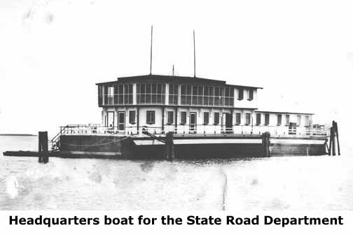
The State Road Department
headquarters
boat was under "Col." Ed H. Sheeran, the Superintendent of Bridge
Construction.
He was a civilian, had served in the military as a major and this title
can be assumed to be an honorary one. He worked under B. M.
Duncan,
Consulting Engineer, State Road Department who normally was in Key
West.
When questioned during the post hurricane investigation he said there
were
"about 30" people aboard the Sarasota during the hurricane. The
following question was "Do you think that is all that could be on the
boat
with safety?" His reply was "That was all - and they weren't safe!" One
veteran survived aboard the headquarters boat.
-
President Franklin
Roosevelt
called for an immediate investigation. Colonel Ijams of the Veterans
Affairs
telegraphed FDR on September 8, 1935: "LOSS OF LIFE FROM SEPTEMBER 2,
1935
HURRICANE IN FLORIDA CAUSED BY TIDAL WAVE, STOP PROXIMATE 250 MPH WINDS
STOP TENTATIVE DEAD AND MISSING 684 STOP WILL INVESTIGATE ..."
The House
introduced Bill 12869
to provide for the immediate cash payment of the certificates to
surviving
veterans and their dependents by extending the provisions of the
Employees
Compensation Act. As part of the process, the U.S. House of
Representatives
Committee on World War Veteran's Legislation chaired by John E. Rankin
made a lengthy hearing from March to May 1936 with many 
witnesses
appearing.
His final report was submitted on May 29, 1936 and the bill came into
law.
A copy of the hearing portion (inquiry) of this investigation can be
seen
at the Islamorada and Key West Libraries.
At the right is my photo taken
from the Channel 2 bridge of the remaining eight concrete bridge
pilings.
The finished bridges would have been an arched bridge like those of
Henry Flagler, but wider for motor vehicles.
Additional
reading
links:
The Florida Keys Memorial (Hurricane
Monument to WW-1 veterans and civilians)
Photos of the 1935 Hurricane
(Natural
History cybermuseum)
1935 Hurricane Homepage
Additional photos taken by
Willie Drye and myself on an expedition in October 2001 follow with
little
text (JW).
 Looking about northeast
in
straight line to where the veteran's camp was. Veterans Island, or the
remains of the approach to the first pier, appears as slight dome in
line
with piers and Lower Matecumbe Key. The automobile ferry landing was
just
right of this line and the railroad just right of it. The second pier
is
often almost submerged. The far three piers were almost ready for the
spandrel
walls for the arches to be installed.
Looking about northeast
in
straight line to where the veteran's camp was. Veterans Island, or the
remains of the approach to the first pier, appears as slight dome in
line
with piers and Lower Matecumbe Key. The automobile ferry landing was
just
right of this line and the railroad just right of it. The second pier
is
often almost submerged. The far three piers were almost ready for the
spandrel
walls for the arches to be installed.
 This view is looking southwest
towards Fiesta Key (Jewfish Bush Key then) and shows two of the
completed
piers.
This view is looking southwest
towards Fiesta Key (Jewfish Bush Key then) and shows two of the
completed
piers.
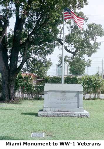 The memorial at Woodlawn Park
Cemetery
on SW 8th Street in Miami, Florida where 80 veterans were interred. The
inscription reads, "Erected by Harvey W. Seeds Post 29, the American
Legion,
In memory of our comrades who lost their lives on the Florida Keys
during
the 1935 Hurricane."
The memorial at Woodlawn Park
Cemetery
on SW 8th Street in Miami, Florida where 80 veterans were interred. The
inscription reads, "Erected by Harvey W. Seeds Post 29, the American
Legion,
In memory of our comrades who lost their lives on the Florida Keys
during
the 1935 Hurricane."
 
The Florida Keys Memorial at
Mile Marker 81.5 on Upper Matecumbe Key commemorating civilians and
veterans
who perished in the 1935 Hurricane. To read more about the memorial, Click
HERE
The most recent
commemoration to the services of the WW-1 veterans is
the official naming
of what now is an island named as Veterans Key. To my knowledge this
island and the eight bridge piers are the only remaining
artifacts specifically of veterans. It is shown at the top-center-right
of the first
photograph at the top of this page. This Key is not a natural Key as
most are. This is a portion of the highway approach dredged up to
connect Lower Matecumbe Key to the eight concrete piers at the time of
the hurricane - a man made island.
The hurricane waters washed out both ends of the approach leaving this
small section near the center to grow mangroves
whose roots trapped more sand and voila' an island. Had the hurricane
not come, it would be part of just another earthen bridge approach.
To return to the Specific
Locations and Keys homepage, Click
HERE.
|