
General History of Indian Key
Welcome to the comprehensive Indian Key Tour.
The Massacre Story
Page 1
By Jerry Wilkinson
Disclaimer: The following is based on the contents of Hester Perrine's diary and Henry Perrine Jr.'s manuscript of which both were published decades later. Therefore, I do NOT present this as factual history. The word "massacre" appears to be a white man's invention where he refers to an event where Whites were killed. If the Whites did the killing (massacre) some other word is used as battle, military engagement, defense, protection, etc. The one exception is the Sand Creek Massacre in Colorado where Congress declared Whites killing Indians a "massacre." J.W.These codes are necessary to follow the site layout maps for Indian Key, Tea Table Key, Lower Matecumbe Key and the ship Medium. Lines of movement or travel plus physical objects are labeled with these codes.
By following the story and referring to these codes, the movement and objects can be visualized. It will still be difficult even if you know the story. Suggest you first print a hard copy of the these codes, the Perrine house floor plan and the site maps. When you read the story these codes are repeated in the story so that you can see and follow the action that is taking place. Remember, during the massacre many things are happening at the same time. The story line can only relate one thing at a time. I have attempted to relate the events in chronological order, but that is impossible.
(Your comments and improvements are welcomed, especially if you are a graphic artist and can improve the visuals.)
There are three elements presented to follow the events of the Indian Raid. They can be viewed or printed so as to follow the while reading.
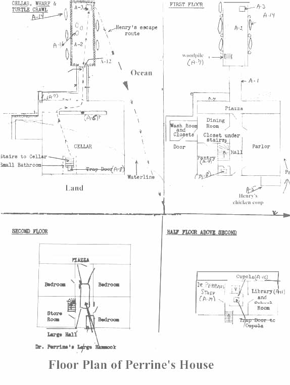
- FIRST is a floor plan of the Perrine house, bathing room and turtle crawl. Click HERE and return.
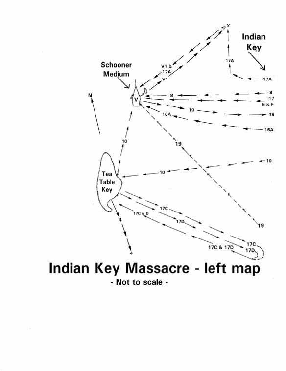
- SECOND are three sheets for make ONE map of the area where the raid takes place. First print the left side of the map, so please Click HERE and return.
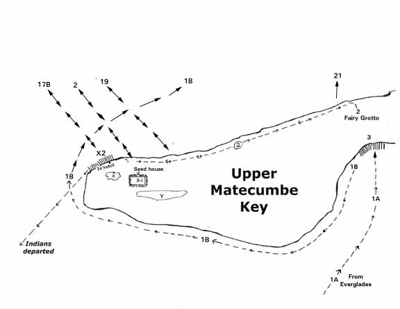
Now print the bottom part of the map, so please click here and return Click HERE.
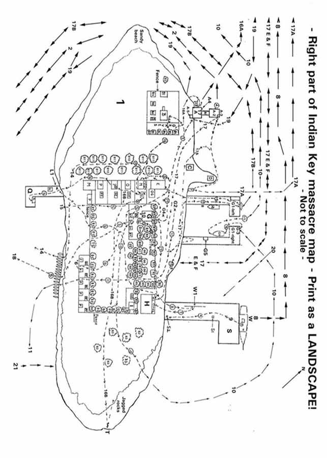
The right side of the map is all of the island of Indian Key. Because of the size and amount of items at this time it has poor resolution. Before printing, it may help to first view the image by clicking Click HERE. At his link the image has been turned to be in landscape format, therefore to print the right side please Click HERE and print.
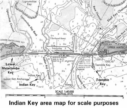
- THIRD is an area map to scale and with a scale which will help in understanding the range of activities taking place during the raid. Please Click HERE.
Since the small details on the right side of the map is practically unreadable at this time, an alternative is is to print the text and view the right map side on the screen.
It will be worth your time to trim, align and tape the bottom, left and right pages as one map. Use a pen and connect the lines according to the numbers. I know the right side is small, but that is where most of the events occur. Colored pencils to highlight the routes will help.- Legend to location codes - A - Dr. Henry Perrine's two and 1/2 story home with piazzas on the first and second floors and cupola on top. Dr. Perrine's family consisted of his wife, Ann Townsend Perrine, daughters Hester and Sarah and son Henry. Entire foundation of house in water at high tide.
(Use of hyphens vary between maps)
A-1 - Passageway appeared to be of solid masonry. In the early days of the Seminole Indian War, a small boat was kept here to provide a means of escape in case of an attack at night. It was 20' long, 5' wide and 5' high. The sides were made of coral rock upon which were laid heavy planks. On these more rocks and planks again.
A-2 - Turtle crawl used for storing live turtles. The top of this and A-1 formed A-4.
A-3 - Hatch located at end of turtle crawl (S-2) normally used for adding or removing turtles for sale or slaughter
A-4 - Perrine's wharf
A-5 - Young Henry Perrine's coop for his chickens and Muscovy ducks.
A-6 - Wall supporting the house saved the remaining Perrines from being roasted alive as the house burned and they remained in the passageway (A-1)
A-7 - Piles of wood on wharves
A-8 - Trapdoor in small bathroom to cellar
A-9 - Pantry
A-10 - Cupola where Perrine was murdered.
A-11 - Library
A-12 - Palmetto Post Barrier
A-13 - Location of mattress where young Henry Perrine slept on the morning of the attack.
A-14 - Canoes used by the Indians to carry away plunder from the Perrine house.
A-15 - Trap door to Cupola
A-16 - Turtles in the crawl.
A-17 - Dr. Perrine's study
B. Charles Howe's low one-story home and buildings. His family consisted of his wife Eliza, daughters Sarah and Amelia and sons Charles, Edward and William.
Other buildings included negro dwellings, kitchen, shop and cistern. His slaves were Jenny, the cook, her daughter Hannah and a son. Mulatto carpenters were William and Peter. Handymen were Old March and Sam. Old March carried the tattoo of his African tribe on his shoulder.
B1. (left of house) Possible location of post office operated by Charles Howe.
-TREES-
B2 - Seaside Grape Trees, B3 - Gumbo Limbo Trees, B4 - Mulberry bushes,
B5 - Palm Trees, B6 - Tamarind Trees, B7 - Lime Trees, B8 - Fig Trees,
B9. Lemon Trees, B10 - Orange Trees, B11 - Paradise and Pride of China Trees
B12 - Howe's Shop, B13 - Howe's slave quarters, B14 - Howe 's kitchen, B15-Howe's cistern
C - Ship Carpenter's shop used by bachelors Glass and Beiglet
D - Blacksmith's Shop
E - Jacob Housman's Store with a room on the second floor occupied by Mr. Otis, and where the six remaining Indians still plundered and loaded their beached boat.
F - Escape boat used by the Perrines which the Indians had loaded with a barrel of flour, box of tobacco, soap, brandy, molasses, corn, a hat and part of a mosquito net.
G - Jacob and Elizabeth Ann Housman's two-story mansion (with cupola), kitchen and negro quarters.
GA and GB - Small boats owned by Jacob Housman
G1- Housman's enclosed docks (left and right)
G2 - Fire built by the Indians near the beach as they plundered Housman's home and store.
G-3 - Elizabeth Housman awaited the return of her husband.
G4 - Jacob Housman was buried in front of his house upon his death about May 1, 1841, while engaged in wrecking.
G5 - Housman's bath house
G6 - Probable location for courthouse built by Jacob Housman in the late 1830's.
G7 - Housman's slave quarters
G8 - Kitchens, storage and outhouses (not privies)
H - Jacob Housman's three story warehouse with a lofty cupola and large cistern in the cellar.
H1 - Piazza for warehouse
H2 - Trap door in warehouse piazza floor
I - State Senator William F. English's house and kitchen.
J - Two room cottage of Mr. James Glass who was employed by Housman as a ships carpenter.
K - Two room cottage of Mr. George F. Beiglet who also was employed by Housman as a ships carpenter.
L - Glass and Beiglet in the starlight discovered a large number of Indians lying all along the fence waiting for daylight before making their attack.
L1 - James Glass, the ship's carpenter, hid here under wharf.
M - Tropical Hotel
N - Home of Mr. & Mrs. John Motte, two daughters and their grandmother, Mrs. Johnson (Age 70). Kitchen N1 in rear
0 - Home and kitchen of Mrs. Smith, her child, Mother (Mrs. Sturdy) and brother Joseph Sturdy
P - Vacant houses and kitchens
Q - Walter C. Maloney's wharf
R - Bathhouse on Maloney's wharf where Mrs. Johnson sought refuge
S - Housman's warehouse wharf.
S1 - Mr. Somarindyke, Housman's chief clerk, fished almost daily from his chair here on wharf S.
S2 - Other sailors from the sloop (W) concealed themselves under the end of the wharf.
T - The location where Mrs. Sturdy and her daughter Mrs. Smith and child managed to reach the jagged rocks on the southeastern end of the island and hid in the water behind the rocks where they remained in the full blaze of the tropic sun until the Indians departed.
U - Henry Goodyear's store and grog shop on wharf Q.
V - Schooner Medium loaded with canoes for expedition into the Everglades to remove Indians
V1. Whaleboat from Schooner Medium
W - Sloop (probably the Key West) docked at Housman's warehouse wharf S for repairs
W-1 - Mast from the sloop under repairs on S
X - Rain water collected in solution (sink) holes on Lower Matecumbe was used by the people of Indian Key during the dry periods, and by the spongers and thirsty mariners traveling through the area. "X" also marks certain other locations.
X2 - Indians gathered here after the attack. Two Indians seeing young Henry Perrine escaping from Indian Key paddled after him.
Y - Indian Kitchen midden abutting mangroves