|
Issue 47 – The Dr. Joe Bauer -2 Edition - Spring 1999 of History Talk of the Upper Keys
- TABLE OF CONTENTS -
1935 - The Great Hurricane of 1935 - Page 697 1935 Keys Hurricane Introduction
By Jerry Wilkinson
[NOTE: There is a small difference between the paper printed edition and this electronic edition as the two medias are difference; therefore, the layout criteria is different - JW]
There have been four books specifically written about the 1935
hurricane excluding the 524 page report on the 1936 Congressional
Inquiry. They are; The Last Train to Paradise by Les Standiford,
The Storm of the Century by Willie Drye, Hemingway’s Hurricane by Phil
Scott and recently published Category 5: The 1935 Labor Day Hurricane
by Thomas Neil Knowles. All four of the books cover the events very
thoroughly while presenting the events in different manners and
perspectives.
This is a photographic effort with a limited number of before and after images. This requires twice as many photos, but in my opinion is a good way to compare the results. Space allocation is an immediate problem when an appropriate size of image is used. My justification is the preservation of the photographs and what they represent if the axiom: “A picture is worth a thousand words” is correct. The details are in the four published books. I will attempt to be as specific of the locations as possible without using landmark names that are temporary. With that said, these are all the sets of Before-After photos that I have, yet I have many unmatched photos. The following are six reasons why this hurricane was significant: 1) Physics - It had the lowest barometric pressure ever recorded over a land mass in the Northern Hemisphere - 26.35 inches of mercury. 2) Government - Florida had 1,458 World War One veterans working on government relief projects of which about half were in the Upper Florida Keys of which about 257 died because of the hurricane. 3) Politics - The rescue efforts of an evacuation relief train failed, as well as itself being destroyed primarily from too late in departure. This failure was blamed on the government’s failure to act responsibly. 4) Transportation - A major transportation rail artery was damaged so severely that it had to be abandoned. 5) Communications - The gathering and relaying efforts of the Weather Bureau failed to serve some of the maritime or terrestrial entities. 6) Loss of civilian life of 228; albeit, not the greatest of record as there were 8,000 from the 1900 Hurricane of Galveston and 2,500 in the 1928 Hurricane of Lake Okeechobee. 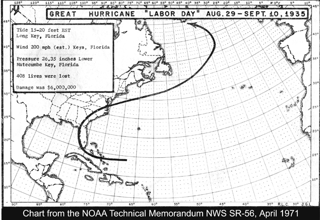 At the right is a small version of the chart showing the path of the 1935 Hurricane. It successfully traveled almost to the Arctic Circle with the most populated areas being the Upper Keys. Click the image to enlarge. The loss of the approximate 228 civilian lives did not seem to stir national concerns. The fact that Miami had three competing newspapers did provide exceptional coverage, especially in quantity, and resulted in fast and effective local relief efforts. At a national level the fact of being well into the Great Depression may to some degree have lessened public sensitivity as almost every one had some degree of hardship. What did capture national attention was the plight of the WW-I veterans who appeared to again be victims of political actions. When the depression seriously got under way with the stock market crash of 1929, the veterans across the country began to become organized for their bonus. A former sergeant named Walter Walters gave a speech on March 15, 1932 which ultimately started a march across the country terminating in Washington, D.C. with about 20,000 strong. This is well documented in books FDR and the Bonus Marches, 1933-1935 by Gary Dean Best and The Bonus Army, An American Epic by Paul Dixon and Thomas Allen. I added another entry in 2007 by officially naming the small island just south of Lower Matecumbe Key as ‘Veterans Key.’ The island resulted from botanical growth on a small bit of the remains of the bridge approach that the veterans were building out to their concrete piers at about MM-73 when the 1935 Hurricane struck. Speaking of populations, I include my second chart before the photos - a population chart of Monroe County. 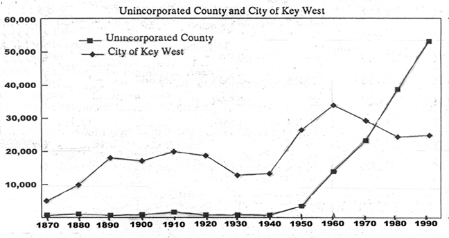 I realize its size is small [Here is a difference in mediums - you can click to enlarge-JW], but the gist is the population of all of Monroe County outside of Key West (shown by the shaded squares) was about 2,000, often less than 1,000, until after 1940. About 1973 the unincorporated area caught up and begin to exceed the population of Key West (shown by the shaded diamonds). Also clearly shown as I have said many times, 1950 verifies the growth outside of Key West - post WW-II. 1935 is not clearly shown, but population was stable in numbers. The Upper Keys was not suffering, presumedly because of the veteran camps. Now to the sets of photos from north to south. - I chose Tavernier, shown at the right, as the starting point as it was the northern most community severely damaged, but still habitable and I have these two comparison photos. 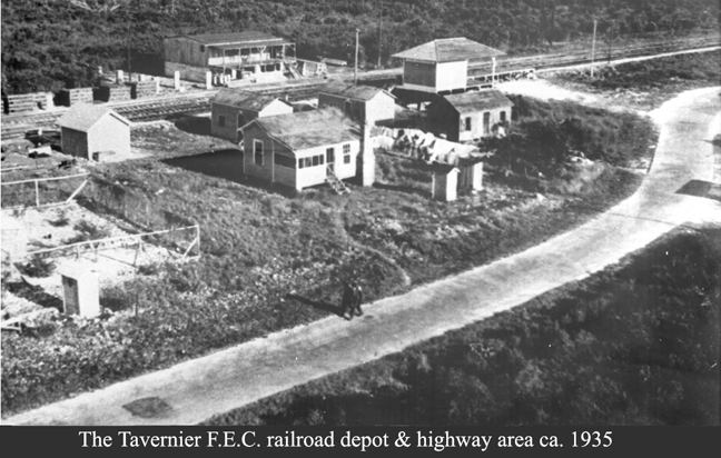 [Note: In the printed version the actual
photos are high resolution 5.5 inch wide photographs - JW] [Note: In the printed version the actual
photos are high resolution 5.5 inch wide photographs - JW]At the photo’s upper right is the railroad freight depot with its loading platform extending to its right with an access driveway from the highway. The depots at Rock Harbor and Tavernier did not offer passenger services. The track passes just above the depot from right to left which is now the southbound lane of highway US-1. There is a large packinghouse across the tracks which is bayside. In the lower portion is shown the old highway with two people walking. The open area below the photo is now Old Settler’s Park at MM 91.8. The Hugh McKenzie business center began only a few feet to the left of this photo. The fenced area is for his petroleum storage area. The lower photo is more or less of the same area, but includes more of the foreground. All that remains of the railroad depot is 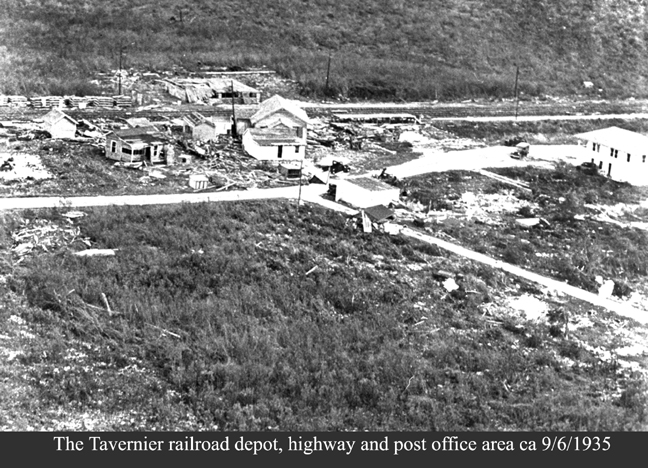 the loading ramp. The larger house
at the center, Merlin Albury’s, had floated over the highway and rammed
the depot building which disintegrated. The packinghouse across the
tracks is in shambles. Except for the small white storage building at
top-left, most of the F.E.C. buildings shown in the top photo are piles
of debris. the loading ramp. The larger house
at the center, Merlin Albury’s, had floated over the highway and rammed
the depot building which disintegrated. The packinghouse across the
tracks is in shambles. Except for the small white storage building at
top-left, most of the F.E.C. buildings shown in the top photo are piles
of debris. In this photo at center-right we see the Harold Albury two-story post office built in 1926 and it remains today. About center is a small building not seen in the top photo and it was the Tavernier School building. The whitish area at the lower right was the house of Roger Albury and whose property today is Old Settler’s Park. The curved portion of highway SR 4A exists today and serves to exit the highway so to enter/exit the park. To the south of Tavernier, Plantation Key was decimated to the best of my knowledge and I have no pairs of before-after photos, so I move to Snake Creek. 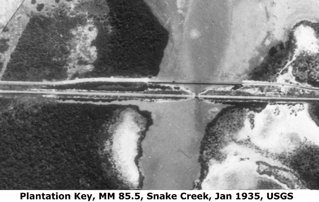 - I have no before photos of Snake Creek bridge other than this image extracted from an U.S.G.S. aerial photo. The ocean is to the top and the bay at the bottom. Tavernier is to the left. Across the middle are two horizontal lines of which the top line is the highway and built in 1927/28. The bridge’s approach was built with wooden piles with a wooden framework bolted to the tops. The highway remained oceanside of the railroad until about MM 80.2. The lower line was the railroad with rock filled approaches to its bridge, two concrete abutments and most likely steel beams to support the tracks. The width of the opening was 25 feet; therefore, most of the total width of the creek was an earthen dam. The grade was 9.3 feet above mean sea level. At the right is seen the damage that the storm surge water did to both bridges. The driven wooden piles remained presumedly because the surging waters could pass between them while at the same time the uplifting effect removed t 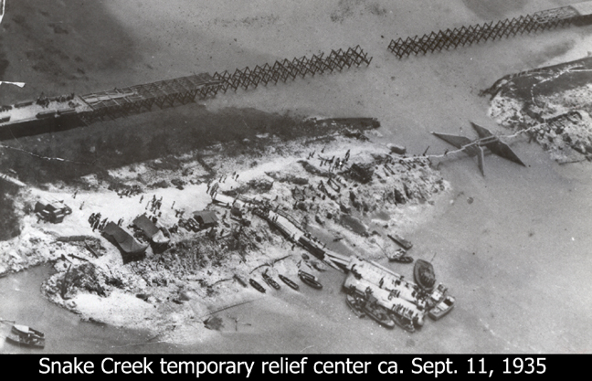 he decking. At
the left end it is seen that new decking is already in process. he decking. At
the left end it is seen that new decking is already in process. Both ends of earthen filled approaches for the railroad bridge were washed away leaving the two concrete abutments in the center. It cannot be clearly seen on this 3.5 by 5.5 inch reduction, but wooden planks were suspended with cables for a makeshift walkway across the creek. There appears to be a pontoon airplane at the lower left. Vehicle traffic could pass to and from this point and a makeshift dock was prepared at the lower center. The dock is relatively large here so I assume the stated date is very close to being correct. This area became the relief and transportation center for the Upper Keys. As can be seen in this photo the railroad bed became a relief community with all forms of shelters used and more were added as time passed. Since I have a lack of ‘Before” photos and the north east side of Snake Creek bec  ame a community
of itself, I will use two more ‘After’ photos. These two photos show
the lower right dock area of the previous page
at earlier periods. By late Friday afternoon there were about 800
relief workers and 400 more by late Saturday afternoon. Most of these
had to rest, eat and sleep some place. ame a community
of itself, I will use two more ‘After’ photos. These two photos show
the lower right dock area of the previous page
at earlier periods. By late Friday afternoon there were about 800
relief workers and 400 more by late Saturday afternoon. Most of these
had to rest, eat and sleep some place.The photo to the right is a Leo Johnson image showing the construction of a ramp down the bayside slope of the railroad right-of-way but no date. They appear to be using new lumber and not debris. The actual dock is said to be a section of the Overseas Highway bridge decking shown at the top of the photo on the previous page and very well could be the missing center section. I am not certain of the details for arranging for this quick quantity of relief workers, their transportation, their support and their pay plus all the materials neede  d, but it
happened. Considering the unemployment in the middle of the Great
Depression probably did not hinder things. I will not suggest exact
dates. d, but it
happened. Considering the unemployment in the middle of the Great
Depression probably did not hinder things. I will not suggest exact
dates.The docking area in this photo appears to be no more than an extension to the ramp. I assume the wooden caskets are empty and being distributed. Then there is the presence of large volunteer pleasure boats anchored, which I understand waned after the injured were removed and the Governor’s decree (September 7th) to cremate the bodies found on-site was made. This area would be about MM 85.8. Note to my referenced Mile Markers: I am using US-1 highway addresses as they do not vary as much as mile markers on maps do. The highway addresses usually are four, five or six digit numbers whose three least significant digits are the structure numbers. Digits to the left of these three are the mile marker from Key West. They are not always correct either, but reasonably fixed. 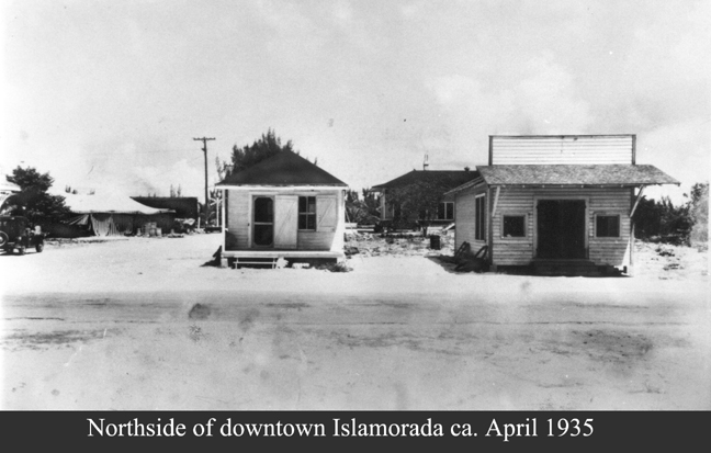 - I do not have great before-after photos for Windley Key so on to Upper Matecumbe Key. There is more on the photo to the right than is seldom seen. This was the commercial center of “Islamorada.” Only the roof’s eave of the post office can be seen at center left. The parked car is in front of it. In front of the parked car is a tent which by the time of the hurricane was replaced by a wooden warehouse. The street in front of the post office and warehouse is De Leon Avenue and leads across the track to home of engineers William Krome and Phillip Wilson on the bay. The gray area at the bottom is the highway - to the right is Tavernier. The small building at center-left is the office for local FERA administrator B.M. Duncan who actually had his primary office at Key West, therefore, his state engineers such as Ed Sheeran. Right of that is the office of the FERA purchasing agent J.G. Gilmer. In back of Gilmer’s building is the Islamorada depot. All this is at about MM 82.8 as is the lower photo. The after photo is from a different angle - looking almost north. None of the buildings shown on the top photos remain other than in the form of debris piled against the wrecked train and the white patterns of their foundations. 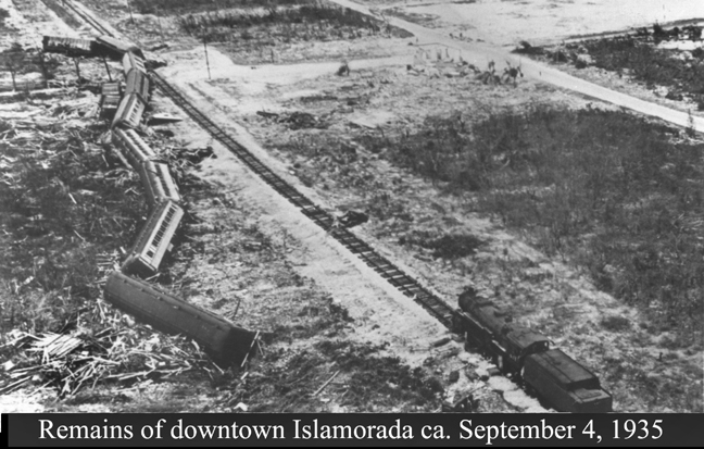 Locomotive 447 and its oil tender are at the lower right facing north as they had been turned around at Homestead. The large white area at the upper right is the ‘mystery school’ - a school to be, but has no documentation. De Leon Avenue passed below it, across the highway, by the post office whose remains can be seen if you look carefully. The post office was made of coral rocks and its remains are at the SW corner of De Leon and the Old Highway. If you noted a power pole in the top photo, it stands alone in the lower photo - the corner of De Leon and the railroad crossing. Nine of the train cars are visible and originally there were a total of 11 - two of the box cars are missing. The elevation of the rail bed was about 8.2 feet at this point. The home of local fishing guide, Leo Johnson, did survive and would be off this photo and to the left of center of the overturned train cars - the only remaining residence in the 40 miles of devastation. Presumedly, the train cars blocked the rush of the storm surge. As we move south the community at that time changed names to Matecumbe.  - At MM 81.8 on the old highway there was a coral rock road that went to three Matecumbe community entities - the Matecumbe church, school and cemetery - all clustered very close together. Since there is only space for one photo I chose the school house. It had a twin building at Rock Harbor which exists today as the coral rock portion of the Moose Lodge. Both were built in 1926. Before this school, the school previously was at the East end of Upper Matecumbe Key. The only documentation I have of it is in the October 4, 1894 school board minutes approving the pay of then teacher, William A. Perpau, $40 a month at the East End Matecumbe School. I have an idea that the school might have been in a wooden church building photographed by one of the railroad photographers in 1909. At the time of 1935 hurricane the teachers were Charles Albury and Ferran Pinder. The Cheeca Lodge occupies this location now and the cemetery has been preserved. The property went into private ownership after the 1935 Hurricane when Hugh Matheson exchanged property he owned bayside for the Works Progress Administration (WPA) to build a new school and the Florida Keys Memorial contiguous with highway at about MM 81.5. 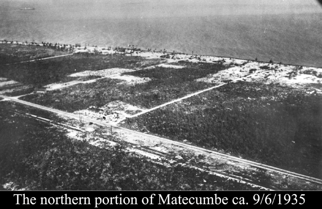 The aerial photo at the right is a large scale aerial taken by the Coast Guard almost immediately after the hurricane. Across the upper portion indicating the shoreline, there are three white sandy areas along the beach. The left white blotch was the school, church and cemetery area. The middle blotch was the Matecumbe Club area and the right area was the homes of the Pinder families. Until the railroad and highway came along most activities were along the beach. A few concrete water cisterns and foundations survived, otherwise all was lost as were the church and school. The cemetery did survive as most of it was at ground level, or below. Barely visible at the upper left is the 321-foot ship Leise Maersk which is aground. Moving inland from the beach, the whitish square at center-left was the Matecumbe Hotel remains. The old highway passed in front of the hotel with the railroad tracks below it. The railroad is shown by the second diagonal white line, The right-of-way for the railroad is now highway US-1 and the old highway remains. The whitish areas represents sand washed from the beach and spread onto barren areas. Locals believe the large white spot at center-left as the remains of a tomato farm that had not grown back. 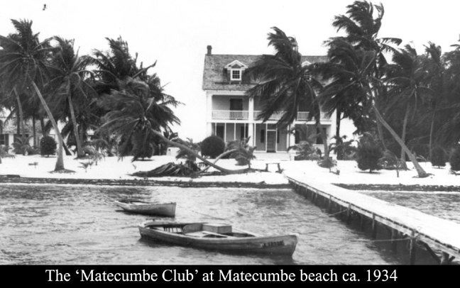 - Matecumbe was the home of a rather unique club considering the times. Wilbur Johnson and Archie Gwathway of the New York Cotton Exchange purchased the ocean site using S.W. Eccels as the builder and completed the building in 1919. It is not clear how it formed, but when finished it was the Matecumbe Club with a membership limited to 14 members - each had to be a millionaire. Locals called it the Millionaire’s Club. The first floor was the lounge area, the second floor had five bedrooms with baths and the loft area was a great dormitory. The building at the far upper left was for support personnel for cooking, cleaning, etc. Bertram Pinder was the club’s manger/caretaker and his brother, Russell Pinder, was the fishing guide. The club had a huge electric generator at the rear of the property and commercially wired for electric service. The Matecumbe Club is also referred to as the Matecumbe Fishing Club, Islamorada Fishing Club and the Millionaire’s Club. The Miami Herald of April 11, 1926 included it in a Keys article of the community of Matecumbe. See History Talk, Issue 30. Islamorada is relatively a new name coming into use with the railroad in 1908.  A surviving photo of its foundation is below. It is a repeat of scenes all along the beach areas which was impacted by the full force of both winds and surge. In general, about all that was found were concrete foundation and water cisterns. Some wooden and other floatable items were found which floated back with the receding waters. The club’s concrete water cistern is seen at the center-right, but it also had a huge elevated water tank to gravity feed water with pressure throughout the club. The mile marker reference is 81.8 It appears that the damaged greenery is beginning to put out new sprouts, hence I assume a few months have passed, maybe even to the spring of 1936. There are two unidentified men in the photo. There is no documentation of the disposition of the Matecumbe Club property other than later Lunsford and Smith Richardson, owners of the Vick’s company, built a large house on at least part of the property. Their house was converted into the Olney Inn by Clara Mae Downey who after it was damaged by hurricane Donna sold it to Carl and Cynthia Twitchell in 1961 who built the Cheeca Lodge. 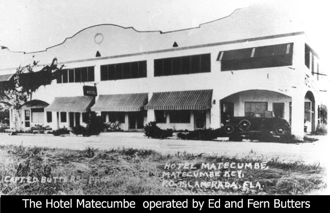 - According to the Butters’ family, Fern and Ed Butters bought the Hotel Matecumbe in 1931 for $80,000 at MM 81.5. The original Mile Markers were called “Mile Posts” by the railroad, they were triangular in shape and displayed both the miles from Jacksonville and the miles from Key West. Anticipating the new Overseas Highway two Key West Russells, Doddridge and Burnell, built the hotel in 1928. A same year business brochure listed Islamorada and Matecumbe separately - as they were then. In Islamorada were: Florida Fish and Lobster Co., Capt. R. H. Russell, Motlow’s Grocery, Russell’s Marine Gas Station, Islamorada Fishing Camp and Ocean View Cafe. In Matecumbe were: Matecumbe Boat Works, Hotel Matecumbe, Rock House Fishing Lodge. The Butters rented the hotel to FERA, but kept the kitchen and dining room. The hotel therefore became the headquarters for operation of the three Veteran Work camps under Ray Sheldon. The state engineering and professional personnel had various other offices, but primarily at the aforementioned buildings across from the Islamorada post office. 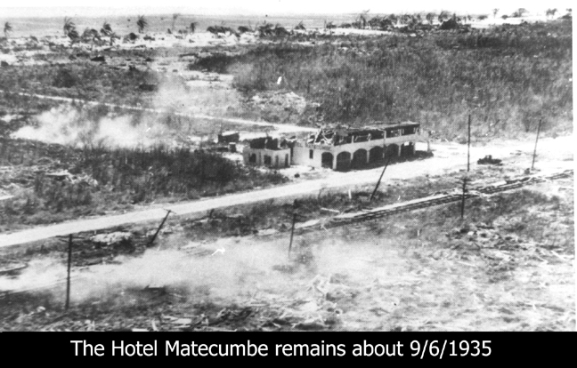 There are four ‘after’ photos of the hotel. I chose this one as it included the Atlantic shoreline which basically extends the previous aerial photo southwards - the remainder of the Matecumbe Pinder home sites. There is nothing new to add here - the shoreline properties were gone. Today (5/3/09) I spoke with Laurette Pinder Russell to verify that I had the order of the shoreline properties correct. She was 16 in 1935 and had attended the school, the church and visited the club many times - two of her brothers worked for the club and she lived on the beach minutes south of its location. In talking about all the properties she again mentioned of how much of the beach sand appeared to have disappeared. It may appear in this photo that the building could have been repaired but this is the ‘lee’ side. Structurally, it would have to be totally rebuilt. They did not have insurance. Again the highway passed in front of the hotel and the railroad next to it. The poles were railway property and was for telephone and telegraph. Other than the Matecumbe Club and Caribbee Colony, electricity was a thing of the future. 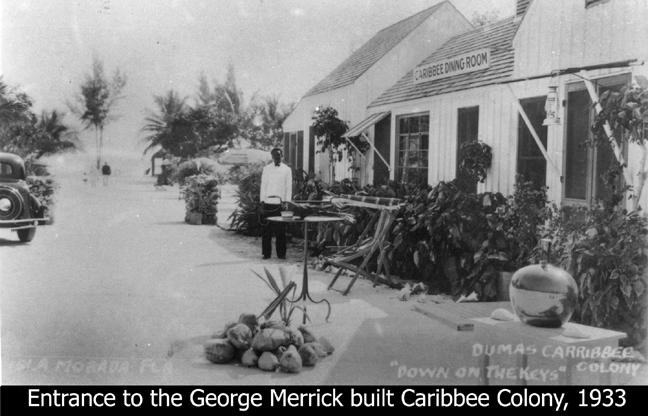 - Another famous place at the time was the Caribbee Colony built by George Merrick, who developed Coral Gables, Florida envisioning a great university. The University of Miami opened in 1926, but the hurricane a few months later severely damaged Coral Gables. His wife owned most of lower Upper Matecumbe Keys and he built the Caribbee Colony as a second project. The estimated completion date is 1930. The photo at the right is a post card. Shown is the restaurant, but it also had cottages, pier, dance hall, thatched palm chickee huts and more. Like the Matecumbe Club he had electricity installed through out the resort, especially a brightly lit over-the-water dance pavilion. Merrick had guests brought down daily in train cars with a quota of 500. His daily ‘South Seas Special’ left the F.E.C. Miami Royal Palm Park Station daily at 9:00 a.m. and returned at 7:00 p.m. The resort was managed by the Dumas family and the advertisements that I have show it as the Dumas Caribbee Colony. The 1935 hurricane destroyed the Caribbee Colony. The entrance to the restaurant shown above was at about MM 80.2 which is the La Siesta Resort today. 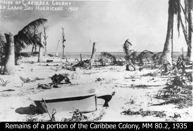 Another postcard image of the Caribbee Colony revealing little difference along the Atlantic shoreline from other post hurricane images. One difference - a cast iron bath tub. Metal appliances such as tubs, cooking stoves, bed frames, etc. were found at other locations. It is believed that there were 26 people at the Caribbee Colony and only four are known to have survived. Wade and Marie Dumas are included in the deceased. In this and the Matecumbe Club after image we see palm trees broken In wet-slow moving hurricanes the water has time to loosen the soil and they blow over. George Merrick continued his family real estate business at Miami which like many more was failing in the Great Depression. He refused to declare bankruptcy in 1940 and became the Postmaster of Miami using a portion of his salary to pay off his debts. - I do have before photos of the three Veteran’s Work Program camps sites, but no ‘After’ photos of the two camps on this  page. Both
encampments were directly on the ocean front, but generally all
inhabitable dwellings were! As we have seen form previous aerials, all
structures along the beach were obliterated. page. Both
encampments were directly on the ocean front, but generally all
inhabitable dwellings were! As we have seen form previous aerials, all
structures along the beach were obliterated. The Federal Emergency Relief Administration (FERA) was created on May 22, 1933 and provided state assistance for the unemployed and their families, and for projects on either public or private properties. In 1934 the WW-1 veterans were included as the Veterans Conservation Corps (VCC), copied but modified after the CCC program. The CCC’s had an age limit of 28 well under the veterans average age of 41 years. Only the states of Florida and South Carolina participated using the WW-1 veterans. There were eight numbered veteran’s camps in Florida. Camp One at MM 85.2/3 is shown above at the right and was the first built; therefore, the oldest. It began with 50 men in November 1934 as an advance party to built cooking and eating facilities. The following week 256 more men arrived to clear and  build
living facilities using what I call cabin-tents - wooden floors and
walls with canvas roofs. They were first called Veteran’s
Rehabilitation Camps, a name quickly challenged by the veterans -
Rehabilitate us from what? The name was changed in April 1935 to
Veteran’s Work Camps. Note at the top center there is an elevated water
tank for running water. Snake Creek is in the background and the ocean
is to the immediate right. build
living facilities using what I call cabin-tents - wooden floors and
walls with canvas roofs. They were first called Veteran’s
Rehabilitation Camps, a name quickly challenged by the veterans -
Rehabilitate us from what? The name was changed in April 1935 to
Veteran’s Work Camps. Note at the top center there is an elevated water
tank for running water. Snake Creek is in the background and the ocean
is to the immediate right. Camp Five at MM 77.4 was built as an overflow site for the primary work Camp 3; therefore, it was the newest camp in the Keys. They continued using the cabin-tents for sleeping quarters, but built wooden buildings for general purpose facilities. The up grading of all the structures was programed. Each camp in the Keys was to provide for up to 250 veterans and were self sustaining other than the hospital was at Camp 1. All three camps were fully operational at the first printing of The Key Veteran News in March 1935. 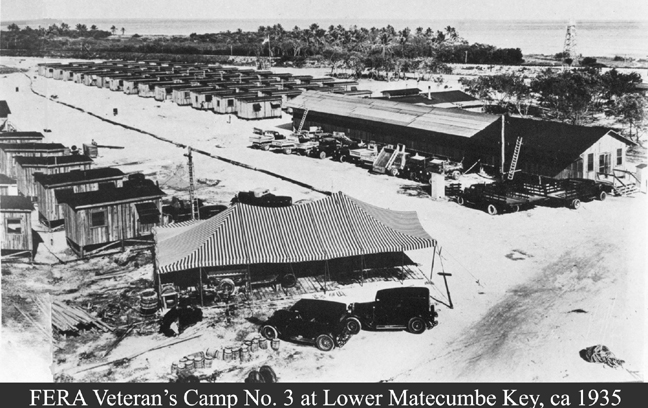 - Camp Three was a living and working site. This was the ‘leaping off point” for the proposed four miles of bridges and eight miles of road to connect to the existing road at northern Grassy Key. It was at the northwest, or bayside of the railroad and highway which are in the background of the photo. At the upper right there is a single wooden water tower very near the main tracks as it was filled from rail tank cars. The large striped tent, and the one on page 702, were replaced by the time of the hurricane. Here we see the absence of the cabin-tents. Progress had taken place very fast considering that the first land clearing in preparation for Camp One was only ten months earlier. What is not seen is the construction area that occupied all the shoreline and the immediate off shore waters where the bridge piers and approachways were being built by state-of-the-art equipment. The shoreline was a mini-seaport for receiving and distribution of supplies and equipment to build an overseas highway to the existing highway at the Grassy Key ferry landing at about MM 59.5. 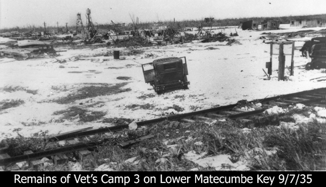 I have three photos of this area to show before I move on to Long Key. There are many photographs of post hurricane Camp 3, but I chose this one since it shows that there was not total destruction. At top right are actually a couple of the wooden houses - not to say that any thing of use survived. One reason for this could be that Camp 3 was on the NW side of the railroad track which formed a 8.8 feet above sea level road bed and starting to climb even higher as it approached the Channel 2 Bridge which was 18 feet above sea level. This earthen dam acted as a buffer dam and also deflected/diverted some of the storm surge northward. The photo below is looking across the island’s tip close to northward at two new steel water towers more or less in the center of the camp from about MM 73.9. They were to be commissioned for use on September 3, 1935. The railroad track just below (to the left of this photo) was upturned on its right side and did not come apart - it was simply twisted. - Camp Three was a large camp compared to the camp numbers 1 and 5 as it also was the working site for the new bridge. Looking eastward from the water towers. Note the ambulance and the assortment of trucks still parked in a row. At center left the storm shutters survived in the open position, unless some one opened them after the hurricane. The large wooden timbers at center-right appear to be reasonably stacked. In the background near the waters edge the railroad track is standing on its side ends still connected as a track. The parked trucks would be above the top-left of the photo below. The aerial photo to the right depicts much of the remains of public and private Lower Matecumbe entities: railroad, highway, ferry landing, Crosland Fish Co., Terminal Inn. Other than this tip of land, all of Lower Matecumbe Key was deeded to four men. 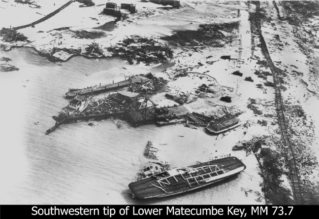 At the right is the railroad track standing on its side at the upper part and laying flat at the lower part. At its lower right is the remains of the ferry boat Monroe County. I believe just above that is the Bradford’s houseboat, but could be the Rowena, a floating bar. At the center is the ferry landing which appears to be usable with a car out on the wooden approach. Just to the left of the ferry landing is the commercial dock of the Crosland Fish Co. of Miami. A hundred or so feet above the ferry landing was where the Bradford Terminal Inn used to serve ferry customers and the veterans. The entire upper left is a small portion of Camp 3. The lower right train track goes to the Channel 2 bridge and on to Craig Key. The upper right track goes to the left corner of the photo on the previous page. The left side is the shoreline of Camp 3. Below that shoreline is Veteran’s Key which was the beginning of the dredged approach to the eight concrete piers. 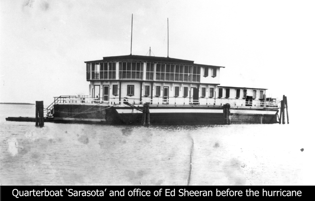 - To the right is the quarterboat ‘Sarasota’ used by Ed Sheeran and his state of Florida State Road Department (SRD) personnel on ‘loan’ to the Veterans Work Program. It has never been made clear how the ‘technical and professional’ personnel, versus the ‘administrative - laborer’ personnel were organized. My take is that B.M. Duncan at Key West was in charge of the former and Fred Ghent at Jacksonville was in charge of the latter. The on-site ‘engineering’ boss was Ed Sheeran who lived at Coral Gables and had done similar work for Henry Flagler. His crew operated the mechanized pile drivers, excavators, dredges, concrete mixers, etc. - about $400,000 of equipment. Photos of some of this marine construction equipment appear to have contractor’s names painted on the sides, but there is no mention of any contractors. It appears that the U.S. government reimbursed only the costs of the actual vet 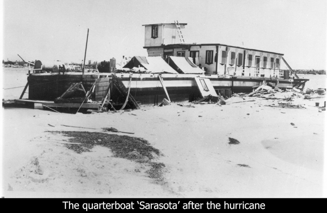 erans and the
state paid all other costs. erans and the
state paid all other costs.The Federal ERA was only created for two years and this was a huge project to begin half way through its contract life. The Works Progress Administration (WPA) assumed FERA’s functions. I have never found primary documentation of operational and organization details of the Florida ERA. The Sarasota was a huge barge with office-living quarters built on its deck. The offices and dormitories were above deck and sleeping cooking, dining, showers, storage, etc., were below deck. Sheeran moved it into Hurricane Creek before the hurricane. The creek, was now more or less a canal, had been used by Flagler as a safe harbor and was redredged by Sheeran. Sheeran had evacuated all but essential and volunteer personnel to the mainland before the hurricane. He had about 30 people aboard during the hurricane - all survived without injury. The lower photo is the Sarasota post hurricane with tents on its fore deck.  - This former construction camp was touted as a stopover in 1908 when daily train services were provided to Knight’s Key Dock. By 1910 it was advertized as the Long Key Fishing Camp. The depot is elevated because of its nearness to the two-mile bridge which climbs to over 30 feet above sea level over water. This was a sizable resort occupying the entire southwestern tip of the island. The 75-room hotel and 14-cabins were on the eastern side between the ocean and the railroad track. The fishing docks, staff quarters, maintenance and support facilities were on the bayside. The large wooden hotel was built at the southern end and cabins were built under palms trees to its north along the beach. Zane Grey stayed in one of the cabins while fishing and writing one of his books. This was the only mandatory rest stop between Miami and Key West. All construction was of wood other than piers and retaining walls. The depot had Western Union service and was an official weather reporting station. Manager James Duane was also the 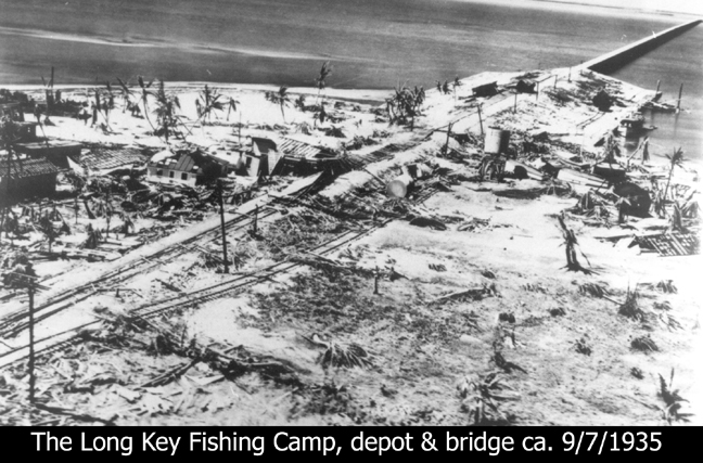 weather
observer. weather
observer.At the right is the Long Key Fish Camp after the hurricane between MM 65.8 to 65.5. As seen the railroad track runs diagonally from lower left (Tavernier) through the camp and to Marathon at the upper right. I believe at center-left is the Lady Ashley house in which the survivors rode out the hurricane. To its right would have been the hotel and to its left the cabins. Across and to the right of the railroad tracks were the docks, maintenance and support personnel quarters. According to Duane at 9:20 p.m. the ‘eye’ of the hurricane passed over Long Key for a duration of 55 minutes meaning both eye walls passed over it. The Corps of Engineers estimated the storm surge was 16 feet, it was declared a total loss yet none to the 20 people perished or were seriously injured - amazing!  The last photo was on the back, or address page of History Talk Issue 47. It is a ground level view of the relief train wreck looking northwards with a side view of locomotive number 447. A temporary track, know as a shoo-fly track, was built through the Upper Keys to retrieve what ever equipment the Florida East Coast Railway wanted. The right-of-way was sold to the state for about $600,000 and the release of some taxes owed. Hope you have enjoyed this form of the presentation of history - JW |