|
- HISTORY OF THE UPPER KEYS
-
I believe that I could
summarize Mr. Krome's letters in fewer words, but for
certain I would lose the flavor of the events; therefore, allow me to
let Mr. William J. Krome tell you from his own writings how he came to
Florida. Also, in my mind it is better 'history' if I do not
subjectively summarize the letters. I do admit because of their
quantity, I
do not include all the letters. His writings will be in italics
and I will follow this style throughout this web page. A series of
periods, ellipses, means I have not quoted the entire document. I
have the actual copies which have been transcribed so the readers can
make their own interpretations. They are also in various
libraries and
museums, obviously not all entities. No doubt I had made some transcription
errors. I usually place xxx if the word is unreadable.- Cape Sable Everglades Expedition Draft - 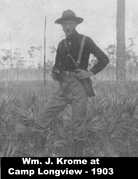 By Jerry Wilkinson - This web page was written in Win XP, but saved and uploaded in Win 7. Be prepared for formatting problems with photos. When a photo is clicked, will NOT return to the same page location on my computer???? I am working on it! Sorry, Jerry 081411 - Disclaimer - I am
posting this site to make accessible some handwritten documents of
William
J. Krome coming to Florida, his survey of the Cutler (Homestead)
Extension and of his survey of the Florida Everglades region in 1902
and
1903. I am
not an expert on the Everglades, or of his surveys there, but I have
incidental knowledge of his works by knowing the Krome family,
interviews
with sons, Bill and Jack Krome, and my research of his survey and works
in the
Florida Keys.
For this web page, I am trying a different style, one of allowing the originator to tell his/her own story as much as possible. I will do an intro, transition paragraphs, quotations in italics but sometimes with explanatory interjections enclosed in brackets [ ] and a closing. Photos will enlarge if clicked - Jerry Wilkinson. - INTRODUCTION -
The Cape Sable
Expedition was chosen by Henry Flagler as his first choice of a route
to build the Key West Extension. Flagler in 1893 had passed a
resolution for his rail company of the time to extend the rail line
from some point of Biscayne Bay to the Island of Key West. His
reasoning in 1893 is not understood as he was then primarily working on
building his Palm Beach hotel -The Royal Poinciana - at least it seemed
so to most.. As he mentioned
building the Key West line from a point on Biscayne Bay, it must be
assumed
that he also had already planned on extending his rail line from Palm
Beach to Fort Dallas area - now Miami. At the time, other rail
companies had similar interests - Key West was the largest populated
city in Florida - I am not suggesting that was his only interest. Key
West
was the only place he built a rail and port terminus without also
building a hotel.
Flagler completed the Miami line in 1896 and in the meantime had bought or built three hotels in the Bahamas and a steamship line to support them. The Miami port was too shallow to receive ocean going ships so a deep water port such as at Key West was desired. He had three options; 1) To build a seaport out into Hawk Channel off of Key Largo as his competitor Henry Plant had done in Tampa Bay. 2) Build a rail line to Key West using a route across the Everglades to Cape Sable, then across the Gulf to No Name Key, then down the remainder of the Lower Keys to Key West. 3) Build the rail line following the Florida Keys to Key West. Option 2 was shorter in distance than option 3 and he already owned significant land holdings at Cape Sable; therefore, this may have been the reason for the exploratory survey to Cape Sable. Even if this had been successful, an engineering survey of the over water route to No Name Key would have to be done. If that was successful, there is little reason that the remaining route from No Name Key to Key West would have been doable. A preliminary survey by a Mr. J.S. Frederick was done for a route to Homestead area named 'The Cutler Extension.' Frederick was also a partner for the team laying out the City of Miami for Flagler. Cutler was a small community east of Homestead named after a Dr. Cutler, but not in the direct line with Flagler's desired rail destination. Flagler owned most of the land needed to construct the Cutler Extension which he acquired in the settllement of the Perrine Land Grant. Mr. Frederick also had done some surveying of survey points westward. A more comprehensive coverage Flagler and the Key West Extension philosophy can be found by Clicking Here and returning here for the details of the actual surveys. Engineer/Surveyor William J. Krome was chosen to perform the engineering survey to present-day Homestead, then to form a 16 man Everglades exploratory cost and feasibility survey team and to proceed to the three Cape Sable regions - East, Middle and West Cape Sable. Another alternative for a general reader is to skip from here to read a Krome written summary of Cape Sable Expedition, then if interested in specifics, return to here. If this is desired Click Here. Before continuing, I wish to step back and bring Engineer Krome to Florida, to his job with the FEC Ry in St. Augustine, sending him to Miami, his forming of a survey team, then surveying the Cutler Extension and finally the reorganizing and surveying the Cape Sable proposed route to Key West. In the early 1990's, I became acquainted with the Krome family and in 1995, my wife and I began borrowing stored written artifacts and making copies. Over a period of time, we copied about 16 pounds of material. In this were a letters, field notes, diaries, photographs, supply lists, etc. At least 250 pages were of the Cape Sable Expedition. Now for Krome's rendition of his coming to Florida: "My first
visit to Florida and
sojourn in the state was, one might say, unpremeditated and very nearly
“Hobson’s Choice”. [A Hobson's choice is a choice in which only
one
option is
offered.-JW] I came to Jacksonville
in February, 1899,
to go to
work for
the Atlantic, Valdosta, Western, Ry. as transit man on a Locating party
which
they were about to send into Georgia. I came down from Savannah in
response to
a telegram from F. W. Long, Chf. Engr, not because I wanted to visit
Florida
nor was interested in the country, but simply because I was out of work
and it
was the only opening that offered....'
After working for various companies at various locations, in 1902 Krome wrote: "... During the late part of July I noticed in the “Engr. News” a paragraph concerning a survey which Flagler’s road, the Florida East Coast Ry, was making into the Everglades. A week afterwards I made a trip of two or three days home and where father informed me that he had just forwarded to me, at Wingartin [?], a letter bearing A.L. Hunt’s return card, I half-guessed what it might mean...." Krome's writings continues: "... The final upshot of it was that on the night of Friday Sept 12, Dusenbury and I left St. Louis via the “Dixie Flyer” for St. Augustine. I secured a place as transit man for Dusen but it order to get away myself had to assume the heavy responsibility of getting up the final estimates for my So. Mo. Ry. work after reaching Florida. We had a delightful trip via the [following are railroad companies-JW] I. C., N.C. & St. L.; G & A, C. of G. G. S. & F. and A. V. & W. Ry. To Jacksonville, where we spent Sunday visiting friends and at noon, Sept 15, reported for duty at St. Augustine...." - Ready for work in Florida -
At St.
Augustine Krome met with the Florida
East Coast Railway officials and was hired. The following he wrote on
page 10 of his journal : "Office
Work in St. Augustine.
The following is
one of his comments on traveling: "...
I do not
think
that
either Dusenbury, or I will soon forget
our trip by rail from St. Augustine to Miami. Leaving the former place
at 11:30
a.m. we reached our destination about 10:30 p.m. The weather was very
warm, the
mosquitoes bad, and the dust and dirt something fearful. The scenery,
for the
most part was dull, although bits along the Indian River and amongst
the orange
groves was quite pretty. We were a thankful pair when we finely stepped
out on
the platform at Miami...."[Sept 15, to Sept. 30, 1002-JW] Upon our arrival in 'Ye Ancient City' we went at once to the engineering headquarters and were warmly welcomed by Mr. Hunt. He introduced us to Mr. E. Ben Carter, the Gen. Roadmaster and Chf. Engr. The latter also received us warmly and outlined to me the work that I would be expected to take in charge. He wished me to finish an estimate of cost based on the Preliminary Survey which had been made. After this work was completed, I was to take a party into the field and make a location for about 22 miles south west of Miami to a point where the Preliminary line turned West into the Everglades. [This was for the Cutler Extension and I am not certain why "22 miles?" There may have been changes after arriving in Miami. After operational, Miami was at Mile Post [MP] 366 and Homestead was at MP 394; therefore, 28 miles- JW] This location finished I would reorganize my party and start on an exploration, beginning at the Southern end of the Location and striking through to Cape Sable. [This portion will be the Cape Sable Expedition-JW] We at once pitched into the work of getting up the estimate and by Sept. 20th had it finished. The next ten days we spent making some necessary preparations for our Locating trip, and awaiting the return from the North of Mr. Parrot, V.P. of the F.E.C. Ry.... On Tuesday, Sept 30, Dusenbury and I left St. Augustine for Miami." - In Miami -
Of Miami he wrote: "... Miami is
truly a tropical city. Situated at
the mouth of the
Miami River, on Biscayne Bay, embowered
in royal palm and palmetto, with an ever summer climate it is an ideal
resort
for the tourist, the fisherman and the yachtsman.Flagler’s big hotel the ,'Royal Palm' is surrounded by large, beautiful grounds and through these and along the Bay Drive we wandered until breakfast time. It was the first time that either of us had ever seen coconuts growing on the tree and we examined the large clusters of green nuts with interest...." After the above mentioned "breakfast time", Krome immediately began making contacts with those who had performed in the Preliminary Survey for the Cutler Extension into the Redlands area south of Miami. With these contacts, he formed a survey team as well as inspected the supplies and equipment left over, and procured additional material. Following is a letter he wrote to his boss, E. Ben Carter: "Camp
Cutler Extension Oct 1,
1902
Dade
Co, Fla.
Yours
respectfully, Wm. J. Krome A.E."E. Ben Carter, Esq. Gen Roadmaster FEC Ry St. Augustine, Fla. Dear Sir: Came out to this camp this morning and have been sorting it out all day. I find the outfit pretty will rundown in the heel and can readily believe Mr. Frederick's and Mr. Harley when they tell of the hard knocks that it had to stand on the Preliminary Survey. I think however, that we will have things pretty well straightened out by tomorrow night and be ready for business Friday morning. The third tent has not yet arrived here and I suppose is still at St. Augustine as I was under the impression that it had already been shipped and did not look it up before leaving. We will need it quite badly as soon as the remainder of the white men show up. If possible I should also like to get hold of a small 8x10 tent for the use of cook and to store supplies. Under the present arrangement all groceries are stored under the bunks of the darkey axemen and drivers an arrangement not particularly pleasant, sanitary or convenient. The present cook, Mose Wilson has managed to cripple himself and say that Dr. Jackson advised him to go to the hospital sometime ago. I will see to Jackson today and if he thinks the injury serious will ship Mose to St. Augustine. A note about E. Ben Carter. He was the highest technical boss of the FECRy. In Krome's writings when he first met Carter, he was titled 'General Roadmaster.' Evidently, he was immediately under the Board of Directors; however, common business practices would have someone also for operations, logistics, sales. etc. Perhaps, Carter was Chief of Engineering. Roadmaster is a railroad title, usually one assigned to oversee a designated district of track. 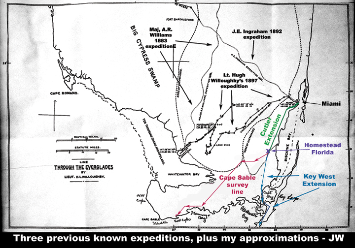 days was spent in collecting a party,
getting up maps and data and overhauling the outfit. I found Mr. [John]
Frederick who
had charge of the Preliminary, a very pleasant and accommodating
gentleman and
I did most of my platting in his office...." days was spent in collecting a party,
getting up maps and data and overhauling the outfit. I found Mr. [John]
Frederick who
had charge of the Preliminary, a very pleasant and accommodating
gentleman and
I did most of my platting in his office...."A note reference previous surveys of the Everglades available in 1902. Much of it had never been surveyed and what had been, the published maps were entirely unreliable. John Jackson was probably the first official surveyor in the area in the 1800's. He did work for the lighthouses, the Perrine Grant, and other general work, but with specific mapping objectives. His routes are not shown on the map at the right. The map shown at the right is from the Willoughby book. Willoughby shows plots for Maj. William's (1883), J.E. Ingraham, president of the South Florida Railroad of the Plant System in 1892 and Lt. Willoughby in 1897. You have to look closely, even if you enlarge the map - it was a large map. All maps of the time period varied greatly about the shape of southern Florida, especially southwest Florida. I would have thought after fighting much of the Second Seminole War in the 1800s, the Army and Navy would have made reasonably accurate maps - not true, or they did not publish them. For decades I have searched for a believable map of the Cape Sable survey. Recently at a meeting I met licensed professional surveyor, Robert Harris, who he and an associate, Douglas Deans, within a week emailed me the following map - marvels of electronics. It is a 25" by 20" court certified copy signed in the lower right corner: June, 1903 and signed by W.J. Krome, assistant Engineer and E. Ben Carter, Chief Engineer, Florida East Coast Ry. To the right is a 72 dpi .jpg copy. 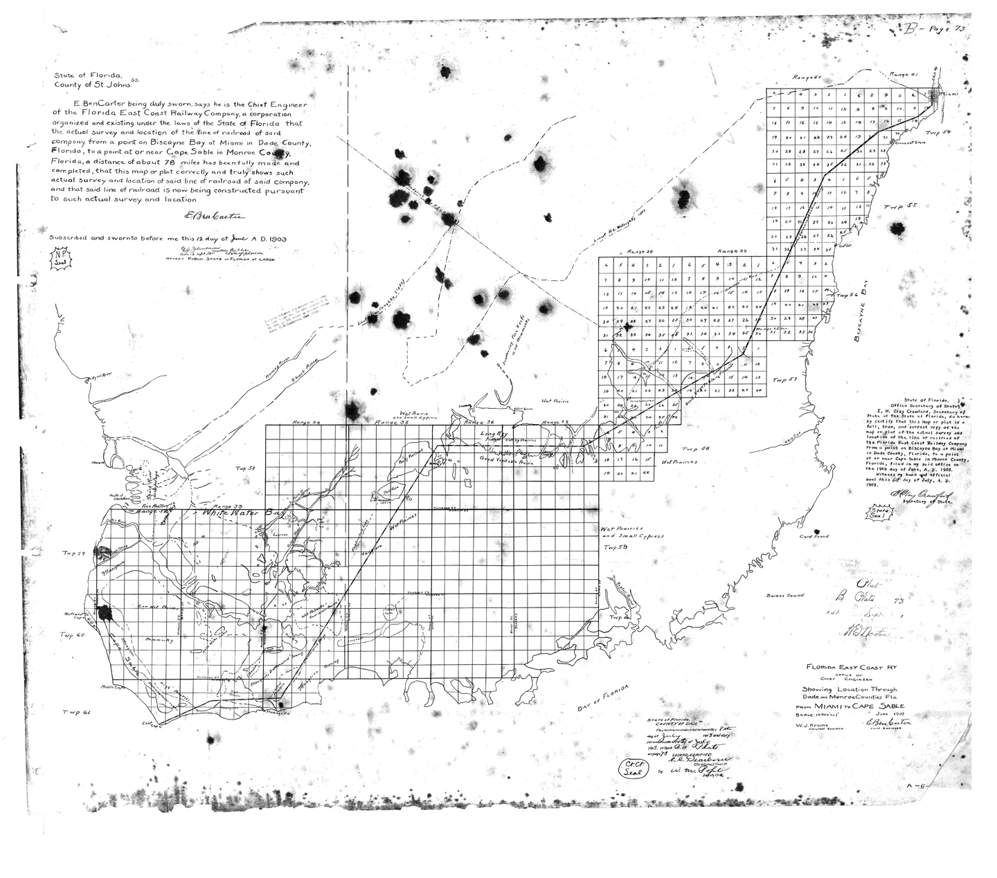 As to the survey line shown in red in the above right map, Krome went almost southwest from Homestead 14.5 miles, then almost due west for 11.5 miles, then South South West for 23.5 miles to about one mile north of the Flamingo Post Office, then about 10 more miles to East Cape Sable. All distances are approximate. It is difficult to show this on the above map as the map is inaccurate. The 1903 FECRy map is much more correct, but I am not writing on it. It also has some Township, Range and Section information. Hopefully by clicking on it you can read some of it - a lot of history on this map, with the court certification just left of the FECRy data. I have no idea how it will print - be creative. Back to Krome collecting his survey party. He gathered his team which he described: " ...In the way of party I tried as far as possible to get hold of men who were out on previous trip with [John S - JW] Frederick. In this I was partly successful...." The final team composition up to when work began he listed as below: "...Transit, Wm P. Dusenbury; Level, Alfred E. Newlander; FrontRod, D.E. Harley; Level Rod, Edwin S. Frederick; Front Chain, Edgar M. Jones; Rear Chain, vacant; Rear Rod, vacant; Rear rod, C.O. Boaz; Axemen (colored); John Henry, John Bryant, Abnir Mc Farlane, S.L. Primus, Cook (colored) Major McKane, Drivers (colored) Will Jones, Joe McDonald....." Transits, levels, rods, and chains are all surveying tools and you probably know what an axeman and cook are. In this case drivers are mule drivers. -
Cutler Extension Survey Starts -
With a survey team assembled, off to work they go to Camp 1 with Krome
writing in his General Synopsis of Events:"...
Additional
tents
were
sent down, new cots and bedding
secured, camp supplies brought in and we were soon on a business
footing. We
found the mosquitoes at 'Camp Miami' or 'Camp No 1' something fearful.
It was
bad enough during the day time but at night they became almost
unbearable. As
soon as it began to get dark we were compelled to build smudge fires
and hug
them closely. We drenched ourselves with 'Citronella' and other
varieties of 'dope' until our clothing and persons were saturated but
the effect was
at best
only temporary and very slight. To accomplish anything in the way of
platting
or computing after dark was an impossibility and even letter writing
was a
burden. We were well supplied with mosquito bars but most of them were
of
ordinary netting and the pests went through them without much
difficulty. Dusen
and I were fortunate in being able to borrow a couple of cheese cloth
bars from
Harley and by tucking these under our sleeping bags we were not
seriously
molested. Newlander, in a huff over a roasting that I gave him for
sponging on
Jones instead of putting up his own bar, tried sleeping with no net at
all over
him but was soon driven to terms by the swarms that settled on him. 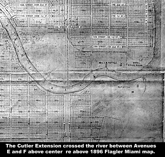 The party began field work on the survey on Friday, Oct. 3rd [1902 - JW] and had the hammock bordering the Miami River to cut through as a starter. A Florida hammock differs from a Georgia or Carolina bay mainly in usually being dry. The tropical vegetation forms a tangle almost like a solid wall and progress in cutting out a line is necessarily slow...." Offering another early map, I show what is known as the Flagler Miami Map of 1896 - see part of it above: In Miami the F.E.C.R. Ry. traveled north and south between Avenues E and F and near the river curved to the east to service the Royal Palm Hotel. The constructed the Cutler Extension continued directly south between Avenue E and F across the Miami River and curved westward rather sharply, then with a series of less radical curves curved back southward eventually to Homestead. See map above right. The following is a letter from Cape Sable Expedition letters to a possible team member [There are other solicitation letters - JW: "Miami, Oct 4 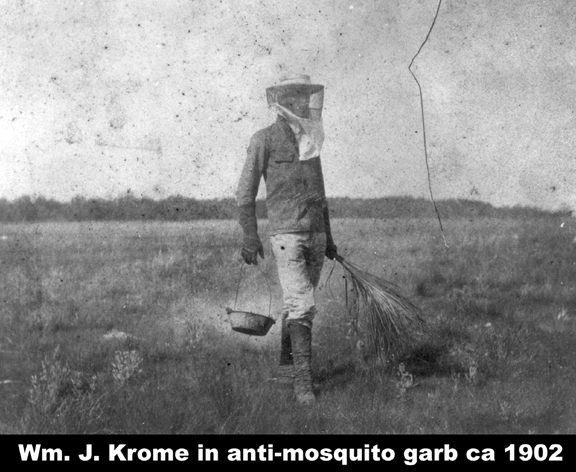 Mr. N. C. Woody Ste Genevieve, Mo Dear Sir- Your letter of Oct 1st received today. I had not answered Mr. Abernathy’s telegram as from its wording I did not fully understand its meaning. My party is complete now, but I can still find a place for you as chainman at $40 per month and field expenses if you want to take it, the better positions as rodmen having already been filled. There is a possibility of a vacancy later on at $50 but of this of course; I can give no positive assurance. If you care to come, wire me at once and get down here as soon as possible. I will have a pass for you at the ticket office, Union Depot, Jacksonville. The location survey will probably last a month or six weeks and there I will reorganize my party and carry a stadia line and exploration through to Cape Sable. Such men as are able to stand the work, will accompany me on this latter work which will probably last all winter. Let me warn you however that unless you are willing to stand extreme privations, endless discomfort and hard work in a region that even the Seminole Indians shun and which no white man has ever penetrated, don't monkey with this job. Every man whom I have with me knows that if he is one of the party who goes into the Glades that here is a very decent possibility of his never getting out. One or two have had nearly enough of it on this comparatively easy work, also I will very gladly make a place for you on the party but don't want you to go the expense of the trip with any mistaken ideas of the character of the work. There is but one redeeming feature to it. There is no malaria or other climate diseases. Please remember me to Bob and tell him that the reason that I gave him before leaving Mo. As to their sending for me to do this work was correct. Yours very truly, Wm J. Krome Asst Eng P.S. If you conclude to come and party is not at Miami when you arrive, Mr. J. S. Frederick, can give you full directions as to how to reach me. Wm J. K." I am skipping some letters especially those for supplies, but there are many letters. Here is another with explanatory information: " Miami, Oct. 8 Mr. E. Ben Carter Gen. Roadmaster F. E. C ry. St. Augustine ,Fla. I enclose a tracing showing our located line through the Brickell property as you see the P.C. of our first curve, Sta. 31105.1 comes somewhat nearer 23rd St. that 24th St. Blocks 97, 94, 90 and South ½ of 85 have not been sold by the Brickell’s. North ½ of Lot 85 has been sold (on sale has been contracted for) to a Mr. Graham, who I understand is an employee of the F.E.C. Ry or one of the allied corporations. As I have located the line, a 50’R/M and 50 Street or West side center will just rub the S.E. corner of this lot. The Bricklell people however are very anxious for us to keep the line as far North as possible where we cut the hammock lots of Block 1 of their addition and I have endeavored to do so as far as consistent with good alignment. If it is necessary to train the corner off of N1/2 Lot 85 I think that it will prove less expensive than any movement of the line Southward in the Brickell Block 1. As at present located I think that they (the Brickells ) are very well satisfied as I have kept our tangent parallel with the street lines as long as possible and have gone the limit on spanning the hammock lots. The subdivision of this property was made by Mr. W. C. Valentine, of Ft. Lauderdale. I understand that he is very accurate and careful surveyor, but I cannot make his map agree with our own, nor his field work check with his platted distances. He shows the depth of Block 1 very plainly to be 2084’ while there measurements made between comes on lot to establish a parallel tangent given is 1958’,1958.5’ and 1958.2’ His map will not tie up with ours along Broadway but I have written him for further information and will probably get it straightened out before time to plat up the location. The party has finished the long curve through the hammock and weather permitting will probably get out beyond Sta, 100 [1.9 miles-JW] tomorrow. I will move my camp out the line Friday or Saturday. [To Potters Mill area which I think would have been the eastern part of the University of Miami -JW] I am considerably in need of medicine as several of the men are seriously troubled by bowel complaints. Hanley has been under the weather for several days and I had to summon Dr. Jackson at 2 o'clock this morning in order to get him relief for him. I sent a coil of large rope that I did not need to you a day or so ago and will send a large sledge up tomorrow as I find that a hammer half the weight can be used to much better advantage. Yours respectfully, Wm. J. Krome, A. E. Here is a letter for supply information as he is preparing to branch away from the Cutler Extension out into the Everglades. As I do not have copies of his incoming letters, I do not know what was received, if anything: "Cutler Oct. 13, 1902 Chief Clerk Quartermasters Dept. Department of War. Washington, D.C. Dear Sir: I am about to start on an all-winter exploration into almost inaccessible portions of the Everglades of Florida. It will be very necessary for me to include amongst my supplies considerable quantities of condensed food and emergency rations. Just where to secure these, I am unable to find out. Can you give me any information as to dealers in this line of goods and as to what rations have been found best adapted to the needs of men working in hot, swampy countries. If this request does not properly fall to your department I would be very glad to have your refer it to someone who can furnish the desired information. Thanking you in advance for any courtesy which you may be able to give this letter, I am. Yours truly, Wm. J. Krome, Asst. Engr. F.E.C. Ry Cutler, Fla." Here is another informative letter: "Oct. 20 Mr. E. Ben Carter Gen Roadmaster F.E.C. Ry St. Augustine, Fla Dear Sir- The transit party Saturday night reached Sta. 780. [My note to this would be 14.7 miles, or about Rockdale or Perrine. 780 means the number of 'chains.' One chain equals 100 feet. So multiply by 100 and divide by 5,280 for the number of miles from his first measurement, in this case perhaps the Miami River??? -JW] Levels about a mile back. Am running level myself as Mr. Newlander poisoned his fist in some manner and was unable to do any field work. As Dr. Jackson thought the trouble serious and I did not wish to run any chances of a bad case of blood poisoning. I arranged for him to return to St. Augustine for medical treatment. Found an error of 1 foot in field work of Parlin levels between B.M’s [Bench Marks] at Stas. 4545 and 4585 [???-JW] which it took a half day to dig out and caused level party to fall behind. Will probably finish the Location by end of coming week and would like full instructions as to further disposal of outfit, men, etc. Do you wish me to bring back everything to Miami or leave as much of the equipment at Cutler as is not needed now but would be essential in the permanent supply camp for the work later on? Of the white men now with us there are only about three whom I could use to advantage besides, Dusenbury. They are men who went through the whole route on the Preliminary and can be relied upon providing they will go. Harley, however is the only one of the three that has expressed a willingness to make the trip so far, and he is not over anxious. We have had rain everyday during the past week and if it keeps up we may not get through by Saturday night. I think however, that we will make it all right the prairies are now about waist deep in water in most places and are steadily rising. I find that maximum high water mark is considerably higher than the elevations obtained on Prelim survey, at edge of palmettos. Have written Mr. McCrimmon as to teams as I do not think we can use them to advantage much longer. Teams better suited for the purpose can be obtained at considerable less cost in the Homestead country. Hoping that you will find opportunity to visit us at Miami soon after you return from your vacation I, remain, Your respectfully Wm. J. Krome A.E. From the starting point on October 3, 1902 on the Miami River, the team surveyed about 30 miles southward, returned to Miami and reorganized in preparation for the Cape Sable Expedition. The trials and tribulations were many as they traversed through the South Florida jungle. Twenty one days later, on October 24, 1902 Krome writes to E. Ben Carter: "Miami, Oct 24 Mr.
E.
Ben Carter
Had we of followed all his
survey
data details from Miami, the Station numbers would have increased in
feet from
his starting point of zero feet. In the above October 24 letter: Sta.
1180 is actually 118,000 feet
from Sta. 0. The number 1180 is the number of
'chains' and a chain is 100
feet. If the measurement is even a number of 'chains',
the last two digits of feet are omitted. To convert "Sta. 1180" to
miles,
we divide 118,000 by 5,280 which
equals
22.348 miles. Many believe that Sta. 1180 was the FECRY depot
at
Homestead, Florida and this could be true. However, on the
aforementioned 1902 map, Sta. 1180 is annotated about 1.5 miles before
he made the westward turn into the Everglades. The annotation is
in section 36, range 39 and township 56.Gen Roadmaster F.E.C. Ry St. Augustine, Fla Have finished locations of the Cutler Extension to Sta. 1180 and have moved camp back to Miami. Will proceed with maps and estimates, awaiting further instructions from you. [Therefore, the Cutler Extension, now known by some as the Homestead Extenson, survey is complete and Krome is in Miami awaiting instructions for what to do next. - JW] Yours respectfully, Wm. J. Krome A.E. - Krome Begins the Cape Sable Expedition/Survey - At Sta. 1180 Krome was to return to Miami, reorganize for the Cape Sable Expedition and return to Sta. 1180 turn westward into the seldom explored Everglades and plot/evaluate a route with cost data to Cape Sable. The above letter was written from Miami and was preparing for our subject Cape Sable Expedition. Krome remained in the Miami/Cutler area until mid December getting everything just as he wanted it. On December 3, 1902 Krome had written E. Ben Carter: "... I
will
remain here to have some alterations
made on the boats and finish my field map. I have been somewhat delayed
on the
latter as I wished to add some data from an old map which I secured
several
years ago when preparing to make an Everglades trip. I had to send
North for
and only received yesterday.
My
outfit now is about complete
and it is certainly a good one. If in any respect we fail it
cannot be
laid to lack of equipment.
On
December 14, 1902 Krome again wrote E. Ben Carter the following: I have secured the man whom I wanted as chief packer and Jenkins who made the trip to Long Key before will go as rear rodman. My men are all that I could ask and they are determined to do what so many other Everglade parties have to a greater or less extent failed in, to bring back results. I will endeavor to keep you informed of our progress at frequent intervals. I enclose payroll, expense a/c, bills for November and stationary requisition under separate cover. If possible I should like to have my copy of “Engineering News” held for me or turned over Mr. Hunt, as I bind each volume and if forwarded hereafter it will probably go astray. Yours respectfully, Wm. J. Krome, A. E." "Camp Sherritt, Dade Co.
Camp
Sherritt was most likely named after Charlie Sherritt and his wife,
her name
not
known, who had already proved their homestead in early 1902.
Homestead did not exist at that time and homestead was in the Redlands
area. The Sherritt homestead is shown at the
right. This will be one of the major relay packing stops, therefore, a
wagon
trail was being built to here. E. Ben Carter, Esq. Gen Roadmaster F.E.C . Ry. St. Augustine, Fla. Party still building roads. Will probably be so engaged nearly entire week. It is slow work but it is useless to proceed with anything else until we have our supply communication well established. Have personally reconnoitered country to South and pine land and have found a very fair crossing to Long Key. Will move camp about 5 miles farther South tomorrow and then one more move will put us to our permanent camp. Jenkins, our rear rodman, is proving quite a valuable addition to the party as he has brought in 3 deer to date and given us a supply of fresh meat. Party all is good health and getting settled into the harness. Yours respectfully, Wm. J. Krome, A. E." The following letter presents some interesting observations of the concept of the Everglades and southern Dade County at that time: "Miami, Nov 16 E, Ben Carter, Esq. St. Augustine, Fla. I received your letter regarding notes on County Road Xing on my return to Miami last night. Mr. Boaz whom I left in charge of camp says he sent you the stations between which we cross the road. It is identical with 20th Street but is not rocked full width. Tuesday morning I started Harley and Wilson in an Everglades skiff on a trip down the East side of the Glades. My object in doing this was to find out whether there was any good open lead from the head of the Miami River to the North end of Long Key or the adjacent pine land. Information that I received Monday makes the chance of getting supplies in from the coast, seem very doubtful. Wilson, rear-rodman, is an old Everglades hunter and said that there was good open water about as far down as the Preliminary line but beyond that he could not tell. Dusenbury, E.S. Frederick and myself with a couple of darkey packers set out in a sail boat for ‘Chis Cut.’ We spent three days down there and thoroughly explored not only the Cut, but every other stream of any size at all that comes into the bay between Black Creek and the head of Card Sound. Chis Cut is the only waterway that amounts to anything at all. It could be made navigable for a good sized dinghy for about six miles but there spreads out and winds up in a number of hammocks. The course of the stream instead of being very nearly West as shown on the maps is South West. It heads up nearly seven or eight miles from the pine land and the intervening prairie is so boggy that hauling or even packing across is out of the question. Harley and Wilson got back tonight and found that they could not get much South of the preliminary line and that only by going a number of miles out into the Glades. We had the worst storm of the season while we went out and had a pretty 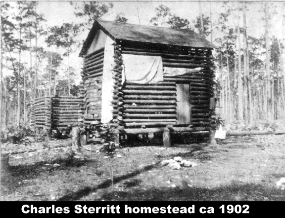 wet time
of it.
wet time
of it.This knocks out the hope that I had of making the major portion of the supply haul by water. The only thing remaining is the overland haul from Cutler. I will send Dusenbury and Boaz down there this week to blaze out a trail and then we will have to do considerable road making before we can get in with the team. Yours respectfully, Wm. J. Krome, A. E." The expedition team will be sixteen men, eight packers of which will be constantly resupplying the eight man survey team. There will be a line of relay points of which I believe Sherritt was the first from Cutler. Let's move on to a December 30, 1902 Krome letter. Note that during this period they had returned to Station 1180 and carried the survey line forward. I believe it is well established that Sta.. 1180 is the starting point for the Cape Sable Expedition. Below is the Krome to Carter letter and Camp Longview was about 10 miles southwest of present day Homestead: "Camp
Longview, Dade, Co. Dec
30
There
are a
number of letters
from Krome as they pass to the new year of 1903. Nothing however is
mentioned of a new years event. We join him in another update to E. Ben
Carter:E. Ben Carter, Esq. Gen Roadmaster, F.E.C. Ry. 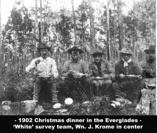 St. Augustine, Fla. Dear Sir- I have just returned from a trip to Long Key where Jenkins and I have been during the past week. We went to the farthest southerly point of the mainland and then crossed over the Key. I followed the South side of Long Key for a number of miles on courses varying from South 75 degrees to due west and did not reach the end there but had to turn back on account of shortness of supplies. Also went some distance North on the Key. The pine land portion is very rocky but there are some fine wide and high prairies and there is also fine prairie for quite a distance along the South side. As nearly as I can tell though, it does not lie much as is shown on the old maps. We found Sheens’ tent and supplies (spoiled by damp) and also located the big royal palm hammock which be reported finding. The main land breaks up into a series of big hammocks islands extending far to the South. During my absence the party started the meander South from Sta 1180 of the location and we will carry it on down and include these hammocks islands by a connecting line. I think that from the point of view of holding up a possible railroad location they may prove valuable. Our supply camp (Camp Longview) is located on the edge of the Glades about 7 miles below the point at which the Preliminary line enters there. We had a long stretch of hard road making to reach this point but it was worthwhile as it is the best place to start packing Westward from that we could have found. We have a good stock of supplies in camp here so that we have not found it necessary to send to Cutler for some time. Nixon will however make two trips in the next 6 days and I will send in payroll, etc. by following trip. Before leaving Miami, I found it necessary to get half dozen heavy blankets for immediate use, and I find now that I should have a least 9 more. The blankets used on the Preliminary were nearly all worn out or lost on that trip and those that I purchased when we started the Location Survey are still in use but are too light for the weather. These Norther’s [It is winter time - JW] that seem to come about once every ten days and last for about four are about as penetrating a cold as I ever experienced. The white men in the party are pretty well supplied with sleeping bags and get along very well but the darkies have suffered considerably. We need for the packers two sets of blankets. The light ones which they now have will serve for such time as they are in the supply camp, but unless they have another outfit in the field camp or at their night station it takes about two of them to pack their bedding along, and we already find that they are not going to be any more than able to keep the field party in supplies. Burdines furnished me with a very good all –wool blanket which he called a cow hunter blanket but charged a high price for them. You could probably obtain them considerably cheaper through your store keeper in purchases. If you could have about 9 of them no matter how rough but heavy, sent to Miami with instructions to forward them to me c/o S.H. Richmond at Cutler it would help me considerably. I have as good a bunch of willing darkies as could be found anywhere and I should hate to lose any of them at this stage of the work. I am leaving here in about an hour to join the party meandering and will be with them until they finish so that after getting the payroll off it may be a week or so before I report again. November payroll checks received O.K. Yours respectfully, Wm. J. Krome, A.E. "[page 62] 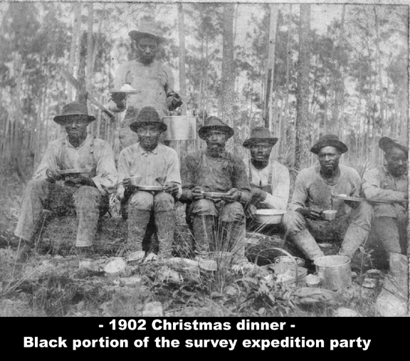 "Camp
Seminole , Jan 12
E.
Ben
Carter, Esq.
We join Krome a couple of weeks later on January 25, 1903. I am not
certain who the Mr. Sheen is. Also note that John Frederick had
also done a
Preliminary Survey this far into the Everglades, much farther than
previously believed.Gen Roadmaster F.E.C. Ry. St. Augustine, Fla. Dear Sir- The field party this week reached the most south easterly point of the pine land and worked some distance West. On the West side along the Glades the ridge extends considerably farther to the South west in a series of large pine islands and big hammocks. Our work during the coming week will be mainly among these. Camp Seminole is located at the head of this chain of keys, within about ½ mile of the Glades W. Discovered two of the original Government corners near the S.E. point of the pine land and tied up to them. They were a surprise to me as I had doubts as to whether any real field work was ever done on this part of the Gov’t survey. Lots of mud and water now but are making pretty fair progress with the stadia work. Respectfully your, Wm. J. Krome, A.E." "Cape
Sable Exploration
Field Camp, Jan 25 E. Ben Carter, Esq. Gen Roadmaster F.E.C. Ry. St. Augustine, Fla. Dear Sir - I have just returned from a two week trip through the Big Mangrove Swamp and the present is my first opportunity for reporting progress for some time. After
out stadia meaner of the Biscayne Ridge had reached
its most southerly point and started North along the edge of the Glades
through
a country which I had already gone over pretty thoroughly. I left the
field
party in charge of Mr. Dusenbury and with Nixon and two colored packers
set out
to cover the unexplored country as far south as the coast along Barnes
Sound.
We took with us two of the steel boats and a two weeks supply of food principally of the condensed variety. My objection point was the source of Taylor River but I wished to cover a strip from 10 to 15 miles wide lying to the South of the pine land. I expected to find open leads of water through the Glades which would finally take me into Taylor River, but in this I was disappointed to find water enough to float our light-draught boats and had to drag them like sleds. In many places the muck is almost bottomless and progress was very slow, 3 miles a day bring all we could make at times. I zigzagged across the belt where I wished to examine and by keeping up a series of packed compass ties got my information in a shape which will make it readily mapped. I found a most God-forsaken region in its present state but one which with proper drainage might yield thousands of acres of prairie with some marl soil of those used for vegetables elsewhere in Dade Co. Much that is showed on maps as Big Mangrove Swamp is not a mangrove swamp at all but a dense cypress land. The timber however is all small and of no commercial value. We found the source of Taylor River and followed that stream to the point where it enters Barnes Sound. The work had taken longer than I anticipated and as I had the information that I was looking for I returned in three days to Cutler along the coast. We had some very bad weather during our trip but found that our waterproof food bags protected our supplies perfectly. The steel boats also gave splendid satisfaction (missing the last line) the pine land meander, tying up with Frederick's Preliminary where it entered the Glades. They are now meandering some prairies but the present week will see this portion of the work completed. We have, to date, made about 70 miles of stadia meander and have secured about all the information obtainable of the Biscayne Pine Ridge, South of the Frederick's Preliminary survey. Our next move will be to tie this meander by a couple of lines with Long Key and then meander that island. From there we will probably carry the line to White Water Bay. At that time I will probably have to change my base of supplies from Camp Longview to some point near Cape Sable or White water Bay as it would require another relay of packers to get in the supplies from this side. The blankets were received during my absence and suit the purpose very well. I enclose stationary requisition for transit books. Party all in good shape and doing first class. Mr. Sheen came through Camp Longview while I was in the Big Mangrove. Told some of the men he had been trying to find a water passage to the Gulf but failed. Your respectfully, Wm. J. Krome, A.E." A short report from the field this time: " Feb 1, 1903, Camp Longview E. Ben Carter, Esq. Gen Roadmaster, F.E.C. Ry. 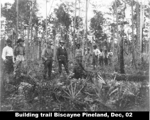 St. Augustine, Fla. I enclosed payroll, deductions, and expense account for January. Bills for this month have not yet come in but I will forward them as soon as they do. We are now connecting our Biscayne Ridge meander with Long Key and will move the field party to the Key tomorrow. Lots of bad country between here and there but after the Key is reached it will be considerably better. Was afraid to trust the Preliminary chaining as a closing line for my meander and had it rechained for 9 miles. 164 feet difference in the measurement. All getting along well and everything moving smoothly. Your respectfully, Wm. J. Krome A.E." This letter to Capt. Roberts established a contract that become important later: "Field Camp, Cape Sable Exploration, Feb 20th Capt. Wm Roberts Cutler, Fla Dear Sir- I am considering sending a boat loaded with supplies to White Water Bay and Mr. C. O. Boaz, my steward has suggested that possibly I might secure your services and your schooner for the purpose. I am now on Long Key and am hauling my supplies overland from Cutler a part of the way and then having them brought in by packers. I will continue to use this method until I finish the Key and start down Shark River into White Water Bay. After that time my idea is to send Mr. Boaz around by water to a point where we can meet him. I will have plenty of supplies on hand to last me until he can reach White Water Bay. I would then want to keep the schooner as a distributing point with the master and Mr. Boaz on board and would also wish to use it as my personal headquarters part of the time. By shifting this base from some point to another as most convenient I could keep my field party supplies with the use of my present pack crew and four steel boats which I have with me. I would need to start Mr. Boaz around –about the 10th of March or a little later and would like to hear from you as soon as possible as to whether I can secure your services, and at what price I can charter your boat by the month. We would probably have use for the boat for about 2 months but just how long of course I cannot be certain. Yours very truly, Wm. J. Krome, A.E." Moving on in time and passing on information about Capt. Roberts, but allow a technical surveying note which will assist in sentence four below. The General Land Office, Washington DC required public lands to be laid off in 'township's of precisely 36 miles square running north & south and east & west. All emanate from Tallahassee; therefore, in line four 'Sec 20' is the 20th square of 36 squares within a 6 mile township. The east-west lines are named 'ranges.' The 36 inner squares are 'sections.' Generally, each Tsp and Sec corner will have a Bench Mark. Any surveyor who finds a known B.M. can make a line to any point within the section. The 'Twp' is the 57th mile south of Tallahassee and the 'Range 38' is 38 miles to the East of the Tallahassee meridian. So with a township map, one could locate precisely the point Krome is referring to. I believe Homestead, FL is also Twp 57S, Rng 38E and Sec 13. Section 20 is about 10 miles west of Homestead which he names as 'Longview.' His camp on Long Key is southwest and about 20 or so miles of Homestead - Long Key is a rather large 'Key' in the Everglades. Here is the letter: "Field Camp, Camp Sable Exploration, Feb 20th 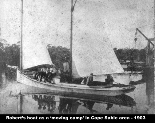 E. Ben Carter, Esq. Gen Roadmaster, F. E. C. Ry St. Augustine, Fla. Dear Sir- Your letter of Feb 10th received and I note your request for information in regard to location of Camp “Longview” I think that my report of Feb 11 will probably have reached you before this, but I will add that as nearly as I can locate it Longview is on the Eastern edge of the Glades in Sec 20 Twp 57 Range 38. Our pine land meander carried us 7 or 8 miles farther South. The location of our present field camp is on the S.E. point of Long Key, nearly South West from Longview about 7 or 8 miles distant. We finished the Northern portion of the Key the first of the week and then moved to this point. Have brought the meander down East side of Key and thence along South side about 7 miles. I will connect today at that distance with a tie line previously run through a prairie from the North. The Key is cut up by numerous prairies many of them fine vegetable land. There is also a belt of first class prairie nearly a mile wide running for 6 miles along the South side of Key. The pinewood is rough and pot-holy to the last degree. The timber for the most part is thin and a rather poor quality of pine. There are many good size hammocks along the Key with a good depth of rich soil overlying the rock. How much farther to the South West the Key extends I have not yet discovered. But think that 15 miles from this point will reach the end of it. We will be in this camp for about a week as there are numerous prairies to be meandered within reach. I also want to run a tie line across to our previous meander a distance of about 3 miles and meander Sheen’s Royal Palm Hammock which ties just East of us. We will then work up the Southwest portion of the Key. I judge that it will take at least three weeks to finish Long Key and then we will head for Shark River and White Water Bay. The problem that presents itself now is that of the best way of getting in supplies while on the West Coast. I am working Nixon and his five packers seven days in the week now getting over supplies enough to keep us going and have a good reserve on hand. One of the homesteaders is freighting our goods out from Cutler to within about 12 miles of Long view and Boaz, the steward hauls them the rest of the way with Nixon's horse and cart. It might be possible to get them across to White Water Bay but with one crew of packers it is dubious. My idea is to get a good supply over here to the Key, cleaning things up at Longview and then send Boaz around by water with a boat load of goods to meet us at White Water Bay. A small fishing sloop or schooner would serve the purpose and could be used as a movable base for our work at Cape Sable and vicinity and afterwards to bring the party back. I would need my present packers and steel boats to keep in touch with the field party but could of course dispense with Nixon horse and wagon. There is at Cutler a Capt. Roberts who formerly lived on Cape Sable and is familiar with the waters in that vicinity and with those of White Water Bay. His information in regards to Long Key I have found more nearly accurate than that of everyone else I came in contact with before starting the survey. He owns and sails by himself or with one man a sponge boat that would suit my purpose and I think that it is probable that I can secure his boat and himself on reasonable terms. I have written him for figures but have not had a chance to hear from him as yet. This appears to me be by far the safest and best way of landing that portion of the work and unless I hear from you with directions to the contrary I will proceed along these lines. In your letter of instructions of last December, I notice that wish an examination made of Flamingo River. None of the maps which I have at hand shows a stream of that name but I judge that I have it under a different title. Is it East of Cape Sable or North of Shark River? If you can give me a clue as to where it enters the salt water I think that I can locate it on my maps. Will need another half dozen transit books before we finish but I will send in requisitions for them as soon as I can get a blank form brought up here. Yours respectfully, Wm. J. Krome, A.E." 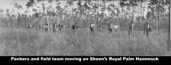 In this letter he corrects the location of Longview from section 20 to 29 and updates other data. Section 29 is the next section south of Section 20. "Field Camp, Long Key March 5, 1903 E. Ben Carter, Esq. Gen Roadmaster F.E.C. Ry. St Augustine, Fla Dear Sir- I enclose February pay roll, personal expense acct. and Deductions. Also a written request for the transit books which I mentioned when I last wrote. My blank stationery requisition seems to have gone astray. I have not received any mail since I reported to you last and will have to wait some days before I can send in the bills for last month. Received expense acct. and deduction for December all right. If it can be so arranged I would like to have January deductions deposited to my credit with Bank of Bay Biscayne, Miami, when I carry an acct. We have had a good deal of prairie meandering and side like work during the past 10 days so that we have not penetrated into much new country. I have kept up this secondary work at the expense of considerable time, throughout all our work with the idea of securing a map upon which a location could be laid at once should it be desired to do so. Our field camp now is on practically the West the meander. I have platted up the outside lines of the Key and lower pine land and fitted then to a sectional map of the country. I had some trouble doing this as my only tie was the blue print map of Frederick's line and I think you will find a discrepancy between the figured and scaled lengths of his last tangent before turning West along the section line. I have now though a pretty good fit between the Government Coast Charts, the sectional map and our meander work. I find that I was wrong about Longview being in Sec 20. It is in the N.E. ¼ Sec. 29-57-38 Our first line from the mainland to Long Key was a prolongation of the South lines of Sec. 29 & 30-57-38 and we struck the Key 5 ½ West of the S.W. comes of Sec 30 this line practically marks the northern limit of the Key. Beyond that it only an occasional xxx or line of hammock 10 ½ miles West of the S.W. corn. Of Sec. 30 we were in open Glades again. From the point where we first touched the Key it extends S.E. The main pine land extends as far South as the South line of Sec. 7 & 8 , 58.38 and 1½ miles West of the S.W. corn. Of Sec 18. The North line of Secs 17 1 & 18 prolonged West very nearly forms the South line of the Key. The distance from the Northwest comes of Sec. 18-58-38 to Long Key due West 3 miles. The end of the pine land takes up nearly 1 ½ miles of this and Sheen’s Royal Palm Hammock about ¾ of a mile more. The point when we are now encamped is nearly 13 miles West of the N.W. corn of Sec 18-58-38 and is very near the West end of Long Key. The Key xxx runs South of our camp about 3 miles and about a mile North. It is fringed out into pretty thin reefs as at the North end. The Key when platted up bears no resemblance to anything that has heretofore been marked “Long Key” on the maps. In fact it is simply a Westward continuation of the Southern part of the pine land broken by a couple of water gaps not over ½ mi wide. White water Bay must also be somewhat different from what is shown by our best maps for Long Key now plats out into the country they show as Bay. From the top of a tall tree yesterday. I sighted what I thought was open water some 4 miles to the S.W. It may have been the Bay. We should be very close to it not at any rate. Just as soon as I can get the use of the field books for a day or so I will finish my map of the Key and send you a tracing but I have to do that sort of work when the chance occurs for as you can readily understand mapping out here is no easy matter in the daytime and at night is an impossibility. We are still packing from Longview but if we go any farther without a change of base. I will have to use the field party as packers about half of the time which will cut down our progress 50%. I have moved nearly a month's rations over on to the East Point of Long Key and can draw on that until we can get into touch with a boat coming in from the West. Yours respectfully, Wm. J. Krome, A.E." 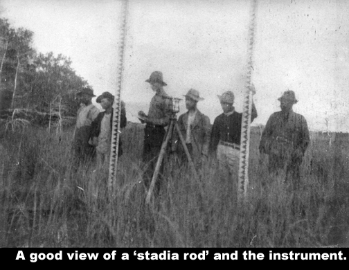 Continuing with another letter eight days later in which indicates that Krome and party have reconnoitered most of the south western Everglades including the Harney and Shark Rivers. This most likely was done in Capt. Roberts' schooner which was now a movable camp. They appear busy taking soundings of which I am not certain in all cases are water depth. Some could be of mud depth. Now the letter: E. Ben Carter, Esq. Gen Roadmaster, F.E.C. Ry. Dear Sir- I am sending Mr. Nixon in on a final trip to Longview today and send you tracing from my field map showing about what we have accomplished to date. The Biscayne Pineland and Long Key are from our own notes and are pretty accurate, the coast line is from the U.S. Charts, pine land north of Frederick's line is from blue print map of Everglade Survey, White Water Bay is from the State land map and as you can see is entirely wrong for we have found out enough to know that the whole east end of it doesn't exist. The small streams shown as Harney and Shark River are probably pretty nearly correct having been located as to latitude and longitude by Lt. Willoughby. Many of our prairie meanders and side lines are omitted from this map particularly on Long Key. Neither has my trip through to Taylor River have been plotted in. I have not heard from you in regard to sending boat to White Water Bay as yet and so am making this the last trip from Longview. Mr. Boaz will return to Miami and after securing a suitable boat will come around to meet us in the vicinity of Shark River. I have given him full instructions and told him in case of any unlooked for difficulty to put himself in communication with you. If you wish to send any word to him wire care of E.L. Brady. If the sounding lines used by Mr. Hunt at Miami are available and could be shipped to Mr. Boaz they would be very useful to us. I found it necessary to discharge Mr. D. E. Harley front rodman, yesterday and he left here for Miami. He flatly refused to pay any attention to a request which I made in regard to a matter of common decency saying that he took orders from no one and I had no option but to let him go. He was a good worker and I was surprised at his action. I can manage without him for awhile and do not think I will have much trouble filling his place with either Jones or Frederick of my location party. We move today to Hammer Island and from there will try another line for White Water Bay; Our post office hereafter will be at Flamingo. Yours respectfully, Wm. J. Krome, A.E." A note re Flamingo before proceeding: I have little documentation of Flamingo, but postal records indicates a 1893 Monroe County post office was at Flamingo. Estimates are that by 1900 about 50 families [May be overestimated - JW] lived in the Flamingo area. On a 1903 approved survey map, his line passed one mile north of Flamingo and turned west to angle down to East Cape Sable. The point he chose at East Cape Sable was about 10 miles west of the community of Flamingo. The following letter actually originated at East Cape Sable. Here he is positive that East Cape Sable is the preferred location for a terminal. "East Cape Sable, May 18, 1903 E. Ben Carter, Esq. Gen Roadmaster, F. E. C. Ry. St. Augustine, Fla Dear Sir- Since reporting to you from Flamingo about a month ago I have had no opportunity to either receive or send out mail. The character of the country has been such that I have had to be in the field constantly, either scouting ahead of the party and blocking out the work or exploring on either side of our meander lines. I endeavored to get a couple of men over to Flamingo about two weeks ago but they were unable to get through the water passage used by Layne and myself on our trip as we had gone in time of a heavy south west gale which banks up the waters up in the Eastern portion of the White Water Bay to a depth several feet greater than is ordinary. The schooner has been busy everyday moving camp or going after fresh water. I have kept our work mapped up only roughly and in a general way and as we hope to finish by June 1st. I do not send a tracing? As I expected to when I last wrote. The work which we have accomplished during the past month has been along the same time that I have tried to carry throughout the survey. That has been to develop thoroughly the belt of country through which a location must pass so that when we have finished we can plat the proper location line and figure with tolerate accuracy on its cost. This bill of course has determined itself as we progressed. A preliminary line was not a practicable way of getting the results as we were working into a country where nothing ahead was known and too little would be learned of the country on each side. With this idea in view we meandered the whole Eastern and north eastern shores of White water Bay and ran line up all the steams coming in from the East or south east. I then carried the meander along the south side of the Bay until we entered the Gulf of Mexico at a point about 6 miles above Northwest Cape Sable. Since then we have followed the shore line around the capes to a point within 3 miles of Flamingo and before we finish we will go a couple of miles east of that place. This gives the outlines of the peninsula lying between White Water Bay and the Bay of Florida, terminating in the capes on the West. We are now at work criss-crossing this belt with line runback from the coast and will thus get close topography of the whole. I found the country south of Long Key and East of White water Bay to consist of wet prairies, buttonwood and mangrove swamps and countless lagoons and salt water creeks. From all maps and other information available I expected to find a solid mangrove swamp lying between the Bay of Florida and Whitewater Bay, but such is not at all the case. The mangrove is dense along the waterways but it seldom extends over a mile back and is more often much narrower. The whole interior of the peninsula is prairie. To the North it is black muck, but along the Bay of Florida is a marl. It is all more or less subject to overflow in times of high tides and southern gales, but along the southern shore is ordinarily above the high water. The last hurricane; 6 years ago, flooded the whole country between the coast and White water Bay except a small territory between East and Middle Capes. At Flamingo it reached a depth of four feet, at East Cape about 6 inches. 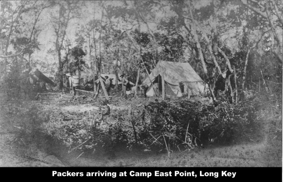 The strip of high prairie hammocks varies along the coast between Flamingo and East Cape from a quarter of a mile to several miles. Right in the vicinity of East Cape it is narrow and a chain of salt water lakes and sloughs extends along the coast from a point 2 miles East of East Cape around nearly to Middle Cape and at a distance of from ¼ mi to 1 mile back from the coast. The East Cape is undoubtedly the point for a railway terminus. The Northwest Cape has no water and no harbor and the Middle Cape, no harbor. Here at the East Cape, a harbor can be obtained secure against anything except hurricanes. The sand banks break the sea and in all winds except south-westers there is smooth water. In south-westers it gets rather rough but can be ridden out with good anchors. In my opinion a good harbor can be secured with a depth of about 12 feet of water at low tide with a comparatively small amount of shell and muck dredging. Deeper water than that would mean rock excavation. The rock gets gradually lower as one gets South of Long Key. It is not the same rock as that in the Miami River but I think that a pile can be driven into it. Considerable filling and protection would be necessary to make a satisfactory terminus at East Cape. but not more I think than at St. Augustine. As yet I have not made close soundings here at the Cape but will probably be ready for that in a day or so. Bradley’s soundings I think are probably pretty accurate but are inclined to slight the channel into East Cape in preference to the line at Flamingo. The latter place is out of the question as a terminus as lacks several of the advantages of East Cape and have a number of drawbacks besides. It will take until, about June 1St to finish the work if we have anything like decent weather and we will all be heartily glad of it as the mosquitoes here are the worse than I imagined such pests could get and give us no peace day or night. Some of my men who have worked along the East Coast say that if all the mosquitoes at Jenius, Ft. Pierce, New Smyma and Jupiter were collected in one locality they would feel ashamed in comparison with this Cape Sable multitude. If there was any way of escape I don't believe I would have more that three men left by tomorrow night. I have directed my mail henceforth to be sent to St. Augustine and would like to have it held there for me. I enclose pay-roll, expenses a/c and deductions for April. There have been no bills for the month to O.K. Yours
respectfully, Wm. J. Krome, A.E."
With the following letter from all appearances it appears that the exploration data gathering for Cape Sable has been completed. "Camp Weaver, May 27, 1903 E. Ben Carter, Esq. Gen Roadmaster F.E.C. Ry St. Augustine, Fla. Dear Sir- We have completed the meander of the coast as far East as Flamingo P.O. and have put in side lines enough to develop the country for several miles back between Middle Cape and Flamingo. I have taken about 1000 soundings along shore and as far out as 4 miles between these points which can be accurately platted and a good many more that were not cut in by the transits. We have about 3 days work yet and then will be through. Will probably leave for Miami on May 31st. or June 1st. Some of the men will return through the Glades, the rest by schooner. Unless we have more favorable winds I shall probably take the Glades route myself. It will take about 5 days to make the trip to Miami overland. Will wire you as soon as reach that place. I suppose that you will want to pay off the party at St. Augustine as nearly all of them want to go to Jacksonville anyhow and I gave them to understand when we started that they would probably be provided with transportation to that point if they stayed with me to the finish. They have earned it. There are a number of squatters between Middle Cape and Flamingo, some of them holding down claims which the F.E.C. Ry. may have a title to. Most of them however are anxious to see a road built through that country and only one raised objection to our crossing his land. The objection in that case was overruled. Party all in working order yet but very much used up by the mosquitoes. Yours
respectfully, Wm. J. Krome, A. E."
The last 17 pages of the collection of data follows. This is what I described at the beginning of the web page as a "Krome's written summary of Cape Sable Expedition." This is not a letter but an article of some sort and he titles it different, but you will find it interesting: (This
is not dated)
"That portion of the State
of Florida lying south of Latitude 25”30' has up to very recent times,
remained
as completely unexplored as the interior of the bet. It embraces the
southern
end of the Biscayne primary, the lower part of the Everglades,
Whitewater Bay
and the Great Mangrove Swamp.[From pages 119 to 137 - JW] A few squatters have for some years raised vegetables for the Key West market on the prairies in the vicinity of Cape Sable but their knowledge of the country to the North of them has been very limited. The few existing maps were entirely unreliable and the reports as to the character of the country by the occasionally trapper or inquisitive naturalist, who had penetrated for some distance into the region, were far from encouraging. Therefore when the officials of the Florida East Coast Railway decided upon an exploratory survey through this territory, with the object of obtaining its possibilities from a commercial view point, various problems rather out of the ordinary, were presented to the engineering deportment. To obtain the information desired it was necessary to cover a brief of two great widths to confine the work to a single center line so a series of closed meanders linked together into a continuous chain was adopted as the trunk of the survey. From this laterals and tie lines could be run as required. The fact that one end of the work was at a known elevation of about 12 feet above mean low tide in Biscayne Bay, the other at Cape Sable on the Gulf of Mexico with a great probability that at no place between the elevation of the country would very more than a few feet from a regular grade one connecting these two points made a line of levels unnecessary. The question of obtaining supplies being one of the most difficult to solve, as small a field party as possible was organized and the stadia adopted as the method of measurement. There is never any trouble in finding plenty of applicants for every position open on a price of explicatory won of this character, but the selection of men who will go the whole route and who can be taught to understand before should that it is hard work under trying conditions and not a pleasure trip that they are going on to is one of the serious problems for the chief of party for this expeditions, men of previous experience field work and of known staying ability were of course given the experience and green material cut out to as great and extent as possible. The choice of good men for the places of axeman and packers was particularly difficult. For upon them depended much of the success of the work and colored labor had been decided upon for these positions. The writer has found the Central Georgia negro about the most reliable of his race for rough work and seven of the eight colored men selected were from that section. The following half year in which these men worked on the average 28 days a month, without a single desertion or complaint justified this belief. The party when completed numbered sixteen men. Of these, eight were in the field crew including chief of party, transit man, recorder, two rodmen, two axemen and a colored cook. To keep them supplied with food and necessaries required a pack party of six men in the charge of a white chief packer. A steward looked after the permanent supply camp and was required to closely keep track of the stock on hand, reporting weekly to the chief of party owing to the irregularity of communication with the nearest source of supplies at Miami, it was necessary to get in orders a considerable time before the goods were actually needed. Each member of the field party was furnished with a stout canvas knapsack and the limit on personal outfit was the weight the individual felt able to carry. This amount was reduced in most cases very shortly as after the first long pack, but probably averaged forty pounds per man during most of the trip. Various materials were tried for field clothing with more or less success. Pantacote sheeting was found too warm for the climate and gave poor service. Canvas wore well and dried quickly after bring wet but is too stiff and uncomfortable to make a desirable working garment. A good grade of khaki, will made, was found to give the best satisfaction, of any fabric tried and has been used with success on subsequent work. It wears will, dries quickly and is soft and easy fitting. Foot gear caused much trouble. Rubber is a poor material for the purpose under any conditions and in a warm climate, for regular wear, will not do at all. The best leather when soaked in water for hours and then pounded over coral reef, Indescribably rough and sharp soon shows signs of grief. Ordinary shoes do will to last a single week. A half boot, lacing to the top through large eyelets (hooks are a nuisance) blatcher cut with billows tongue, a heavy sole and stiff counter can nearer meeting the requirements than any other type. The soles were kept thickly studded with hob nails and the uppers were pierced well down to let the water out. To keep it out when wading waist deep was impossibility. The mosquito plague being one of the most serious obstacles that was uncounted, each man was provided with a bar and the proper starching of these became quite smart. Almost the best tar for this purpose is made of cheesecloth with a canvas roof. The canvas top should be 1 foot long by 3 feet wide with loops or grommets at the corners. The cheesecloth should have a depth of about 5 feet and be sewed to the underside of the roof, leaving two inches of the canvas projecting all around. It this projection is stiffened with buckram or by doubling and the roof of the bar stretch flat when pitched it will shed a light rain quite well and the water will not run down the sides. These nets may be stretched from a stake at each corner, or by putting in a spreader across the ends, two stakes will answer. Head nets are uncomfortable affairs at best, but the use on this work was at times imperative. cheesecloth and bobbinet are too hot and are very hard to see through. The net that was most satisfactory was the worn by the Cape Sable squatters. It is built for use over a stiff round hat and consists of a band of 10 oz canvas, fitting closely around the crown of the hat and extending out to the edge of the rim. To this is firmly sewed a strip of close mesh copper wire netting extending down about 3 inches in the back and curving over the shoulders to the level of the wearer's chin. Cheesecloth is taped on around the bottom of the coppengauge of sufficient width to tuck will inside the coat which is buttoned over it. The win netting is kept out from the face by the stiff brim of the hat, allows the air to pass through freely and can be seen through with ease it being possible to run an instrument quite well from inside one of these gilded cages. When not in use no strings to become knotted or broken loose. It is however somewhat troublesome to carry. A wagon trail was broke out from the of the east, homesteader (I think was Sherritt's place) through the rock reef forming the Biscayne pineland to a point near its southern extremity and then a base of supplies was located. To this point goods could be hauled in light loads by wagon, but beyond it everything was advanced to the field party by the packers, until the White water Bay region was entered when connection was made with a relief schooner. To as great an extent as possible, all provisions were put up in duck bags waterproof with paraffin. These bags were of two sizes, holding about five and ten pounds apiece of such provisions as rice, beans, or meal. They in turn were placed in specially water proof canvas pack sacks and their contents seldom showed signs of dampness even after long exposure to the weather. Regular leather pack harness was used in handling the loads. The weight that could be carried by a packer varied of course with the length of the journey and with the character of the country to be traversed. Under favorable circumstances packs as heavy as ninety pounds were brought in over a trail five miles long, at other times, through pot-holes as deep muck twenty-five pounds was heaving load. A 14x16 wall tent, without fly, makes about as heavy a pack as should be put on a man even under the best of circumstances. Boats were a necessity in transportation supplies although the water in the southern portion of the Everglades is usually very shallow during the dry season of the year during which the work was carried out. The dugout of the Seminole Indian is too heavy for carrying and canvas or Canadian canoes are too frail to stand dragging when loaded. So 14 foot steel duck boats were used and served the purpose admirably they were light enough to be readily carried by two men across portages and three men could drag one loaded where only on few inches of water covered the muck. By using a couple of these boats as sleds, with two men harnessed in front and one pushing with a pole from behind the six packers could bring in twelve full sized packs through muck and water where 40 pounds would have been a killing back load. The food was confined mainly to such articles as could be sacked under this head come rice, grits, several varieties of beans, oatmeal, coffee, sugar, salt, flour, meal tapioca and evaporated fruits. Tinned meats, evaporated cream, baking powder and other canned goods were used to some extent buy they make an awkward pact and were dispensed with as far as possible. 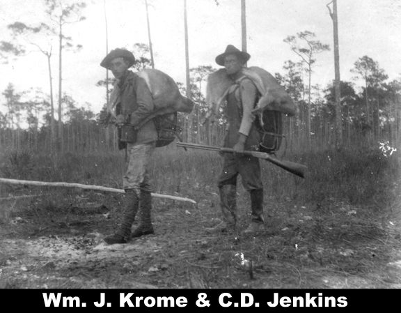 Pilot
bread saved the use of an oven and was our staff of life. Fresh meat in
the
form of venison was easily obtained during the major portion of the
trip, but
fresh vegetables were unknown on the menu. Pilot
bread saved the use of an oven and was our staff of life. Fresh meat in
the
form of venison was easily obtained during the major portion of the
trip, but
fresh vegetables were unknown on the menu.An emergency supply of condensed foods was carried and on several occasions was drawn on heavily. This class of goods is largely imported from Germany and can be obtained in considerable variety. Soups of a dozen kinds, all tasting alike are put up in xxx pockets packages, vegetables of as many sorts, evaporated and compressed until they resemble a good grade of plug tobacco, sliced potatoes as hard as bone. pimdye sausage and evaporated eggs were given a trial. The potatoes after being soaked is an excellent substitute for the fresh articles and the soups, properly prepared are nourishing and palatable but it require a very hungry man to relish the vegetables or eggs. The field party traveled as light as possible. Tents were abandoned after leaving the pine land and a couple of flies used to protect the goods and as a shelter in heavy rains. All cooking utensils were of aluminum and a complete outfit for eight men rested in one pot and weighed hardly 15 pounds entire. A tin box such as is used for fishing tackle and containing a supply of needles, thread, copper wire, awls, beeswax, scissors, screw drivers, pliers, copper rivets and various odds and ends was in great demand and took the place to a considerable extent of the usual camp chest. A similar box held drafting materials and a steel straight edge, an 18” rolling parallel ruler, and a small drafting band completed the necessarily meager office outfit. Medicines were carried in what is known as a country doctor buggy care. Made of heavy sole leather with a compartment for surgical instruments and bandages and fitted with a good number of various sized bottles, it answered the purpose well. Such a case is much the same size and shape as the ordinary 4x5 camera and sling over the shoulder does not add greatly to a pack load. The stock of medicines was selected to meet the needs of the climate and could be replenished from a supply at the permanent camp. A surgical kit containing several lancets, scissors, forceps and flesh needles and a twist or two of silk was ample for our needs and came into use several times. Small pocket cases each holding a hypodermic syringe and two small phials are filled with a 10% solution of permanganate of potash and the other with 1/50th grain tablets of strychnine, as an antidote for snake bites were distributed amongst the party so that one would always be at hand if needed. The climate was healthy for the water in the Everglades is pure and fresh, and malaria is an unknown quantity, So by keeping watch of the men pretty carefully and meeting ailments before they had made much progress, the party was kept in splendid trim during the entire six months and no time was lost having a big sick roll. Sleeping bags of light felt with a waterproof canvas cover were used by most of the men and were very satisfactory. As no cots were carried, and boughs fit for bedding were seldom obtainable, the usual mattress was a pile of sawgrass. Dry camping places were the exception and as the mosquito bars were often pitched in the open, the canvas covers of the sleeping bags were often perched in the open, the canvas covers of the sleeping bags were a double protection from rainfall and from the wet ground. Rolled up with the mosquito bar inside, they were carried on the owner's back when on the move. The machete was used for clearing line, opening up camp sites in the jungle, cutting sawgrass and for every purpose for which the axe and the brush hook are usually needed, except the felling of large timbers and the driving of stakes. It is strange that this useful instrument has not come into more general use, as it can be handled much easier, has no helve to break and as far as my experience goes, it is of a great deal better metal. Axe men are prone to lose brush hooks by misplacing them while using the regular axe, but the machete may be carried in a sheath hung from the belt without hindering the movement and need never be laid down while in the field. The stadia (could be an instrument or a method of measuring distance) was particularly adapted for this piece of work. It allowed a small party to do the work thorough and took the place of the chain or tape where the use of the latter is some cases would have been impossible. There are stretches miles in length through the Everglades where stake wood of any kind can be obtained and whenever the hubs necessary for the stadia work had to be carried long distance. This would have seriously handicapped regular stationary and ordinary marking pins would have been useless on account of the depths of water and soft muck. While the White water Bay region was reached, numerous streams, islands and stretches of coast were meander when the dense mangrove swamp extended out into the water for fifty feet or more beyond the shoreline. As a mangrove swamp is about as hard to cut through as a solid wall, a chain survey would have had to work making half a mile a day. By zigzagging the stances and cutting from one projecting point to another along the coast, the stadia party, operation from the boats, made 3 ½ to 4 miles per day, regularly. Special 12 foot rods, built as light as possible were designed and canvas covers furnished to protect them when not in use. A steel tape was kept in camp and when the chance offered a few of the longer sights were tested by careful measurement as a check with adjustment of the wires. One radical department form usual methods which will probably shock stadia theorists, was made early in the survey. The country was so level that after the first few miles the reading of the vertical angle was abandoned entirely. This simplified instrument work somewhat and reduced to a minimum the lab work of computing the length of sights. It certainly did us seriously impair the accuracy of the results for a carefully chained location which has since been run through a considerable portion of the territory, checked out with the exploratory line remarkably well. Good instrument points were as a rule, hard to get, and it was no uncommon occurrence for the tripod head to be at the water level with a footing of soft muck that increased the probable error in angular measurements alarmingly. A computed bearing was carried throughout and any sudden deviation from the needle would quickly point out any mistakes or large error in taking the angle sights of from 600 to 800’ were about the usual length. When meandering streams the average would be shorter while we work along the coast, where the failure to secure some projection point might mean half days heavy chopping around the shore of a cove, sights of over 2,000’ were occasionally made and the readings taken in halve. The closed traverse, after being balanced were plotted from the same system of coordinates and the tie line and laterals wee built up on this truck. The field map drawn on heavy canvas-backed paper, was platted to a scale of 1”=5000’. As the outline of the whole south end of the state had been previously put on from the government coast survey charts, the position of the party could be learned at any time and the work ahead blocked out. Continual scouting ahead was necessary and in these trips seldom more than two men took part, enabling the field party to continue their work without interruption. As such expeditions often lasted several days each man carried a light pack containing sleeping bad and mosquito bar, one or two small aluminum cooking utensils and a limited supply of provisions. A leather haversack held flag cloth, a ball or string cord, note book and a pocket compass with folding sights. A pair of Treder binoculars, machetes, rifle, and belt of cartridges completed a load that by night fall seemed to its bearers only fit for a two horse team. A start was always made from some point on the stadia meander and careful record of courses and approximate distances kept. When the new territory had been penetrated for some distance trees were climbed at intervals of about a mile and observations made in every direction from them. The lack of a pair of light steel climbing irons, such as are used by ornithologists, was keenly felt but this need had not been foreseen when the outfit was gotten together. As the trees used were often lone pines on some isolated rock reef it was no mean task to shim up them. The observer carried the ball of cord with him and could then haul up the pocket compass, field glasses and notebook. Bearings would be taken on as many known points behind as could be observed and there the character of the country ahead in several directions noted. Before descending, a flag fastened to a sapling, was hoisted and securely lasted in the top of the tree. The tree was then marked with a blaze of the survey along chop with a hack above and below. If the territory developed by this system of scouting proved to be important it was more fully investigated by a stadia line, if not it could be plotted up with sufficient accuracy for the purpose in view, point the notes already obtained. The party was in the field for the first of December 1902 until the early part of June 1903. Trail building and the establishment of a base of supplies held back the work for a month and in the remaining few about 300 miles of stadia line was run besides accomplishing considerable work in channel sounding. The exploration was under the general direction of Mr. E. Ben Carter, Chief Engr. Of the F.E. C. Ry. The most serious obstacles encountered were the heavy muck and dense sawgrass of the Everglades. And the jungles and mosquitoes of the White water Bay region. The muck with proper drainage will eventually become fine farming land and the mosquitoes will disappear to a great extent as the country opens up. The malaria breeding species of this insect is evidently not present for that disease was conspicuous in the party by its absence. As a result of the expedition the lower extremity of the Biscayne pineland was defined, Long Key, a pine land of some (lying in the Everglades) 18,000 acres the very existence of which was previously doubted, was thoroughly mapped. White Water Bay was reduced to one half the size shown on former maps and two thirds of the area known as the Great Mangrove Swamp was discovered to be open prairie. The following table complied from the closed traverse may be of interest to those who have had stadia work to carry on. Total Total # # Closing Total Error Average Length Miles of Instrmt total closing for length Traverse of Sides Pts. Computed error 1000" of TITLE Feet traverse - - Brng. Feet Trav. Sig? Biscayne Pineland 206966 39.2 85 359 0.14’ 165 8.0 5765 Connecting Link #1 106418 20.5 28 152 0.11’ 79 .74 700.1 Long Key #1 120210 22.8 37 169 0.13’ 121 1.01 7113 Long Key #2 59450 11.3 15 76 0.7’ 38 .64 782 2 Long Key #3 30126 5.7 8 40 0.3’ 94 3.1 753 2 Long Key #4 38112 7.2 14 51 0.5’ 42 1.10 747.3 Hammer Island 23420 4.4 6 31 0.3’ 16 .60 755.5 Connecting Link #2 87281 16.5 127 138 0.28’ 141 1.62 637 Whitewater Bay #1 39958 7.5 67 61 0.19' 32 .80 655. Whitewater Bay #2 19804 3.8 18 18 0.4’ 14 .71 1100. Coot Bay 94771 17.9 7 8 0.1’ 45 3.04 1846.5 Peter Prairie #1 10681 2.0 10 16 10.0 8 .75 667 Peter Prairie #2 13190 2.5 11 18 0.8 23 1.74 733 Black Creek 96144 18.2 67 27 0.8 87 .91 157" - - - - - - - - - - - - - - - - - - A piece of trivia: East Cape Sable is the southernmost point of mainland in the U.S. But, I am perplexed at the next letter in the package and is dated August 27. 1903 for a list of medicines for another location Party Survey. My only answer is that it took June and July to finish up the Cape Sable expedition. Regardless, I am including this letter for your consideration, The list was a typical vertical list that I converted to a sentence separated by a semicolon: "August 27, 1903 E. Ben Carter, Esq. St. Augustine, Fla. Please have the following medical supplies sent to me for use of location Survey Party: 6 oz. Comp cathartic pills; 6 oz. Cascara-compound pills; 8 oz. Warbings pills; 4 oz. Cold tablets, 4 oz. Dyspepsia tablets; 4 oz. Headache; 4 oz. Permanganate of potash tablets; 2 hypodermic syringes; ½ oz. Strychnine or other heart stimulant in tablet form for us with hypo syringe for rattlesnake bites; 8 oz. Quinine tablets; 2 oz. Anti banica; 4 oz. Typhoid; 4 oz; Carbolic salve; 1 oz eye medicine; 8 oz cholera mixture; 2 oz. Chloroform; 2 oz half and half mixture iodine and accouter; 4oz. Anti boil remedy; 4oz. Bismuth Sub-nitrate; 8 pkg. Bandages (assorted widths; 4 oz. Antidote ptomaine poison; 8 oz. Powdered slippery elm bark; 4 oz. Absorbent cotton; 1 pint liniment; 2 droppers; 4 oz. Remedy for Bilious colic; l6 poison plasters; 4 oz. Lotion for burns and scalds. Yours respectfully, Wm. J. Krome, A.E." After completing the Cape Sable expedition, Krome returned to Miami. In his writings, I find letters I think were for a Black Creek Project, including cost data. I have no knowledge of this survey other than his letters, but from old maps there was a Black Creek at Black Creek Point on the coast. The costs he gave were: "Cutler Ext =$954.17 & Black Creek Ext. =$295.85." If anyone has knowledge of this please advise. After that, Krome was out of work. My knowledge is now from his 1904 diary where on January 1st he met with Mr. Ingraham who was leaving "...for the north...." He decided to remain in Miami. His father came to visit in Miami and the two went to St. Augustine. While in St. Augustine, on January 29, 1904, he visited the office of E. Ben Carter who sent him to the office of Mr. Parrott. While there he was hired to survey a line for a rail terminus to be built in Turtle Harbor in the Carysfort area of Hawk Channel. Nautical charts of the Carysfort area show a finger of deep water protruding into the Turtle Harbor area deep enough for ocean going ships. This was another attempt for Flagler to have a deep water seaport. At he time Miami had about a 9 foot channel through Biscayne Bay. On March 5th he received a letter from Carter to "... report in person at St. Augustine as soon as we reach Turtle Harbor...." On March 10th he received another letter from Carter "... to omit the Turtle Harbor soundings and report on the line as soon as finished...." On March 21st he left Camp Buttonwood on Little Cardsound Point for St. Augustine, but while at Palm Beach he was called to the depot's platform by Mr. Flagler whom he gave "... a hurried catechism on what I had found below...." Krome continued on to St. Augustine to meet with Carter. Things went back and forth re Turtle Harbor and a route down the islands. In his diary he wrote on Friday, March 6, 1904 "... In the evening Mr. Carter announced that the work would go ahead for certain. This settles matters for some months at any rate...." It was not until May 6, 1904 that the absolute 'go ahead' was given to form a survey party for a preliminary line from Homestead across the Cross Key route (The 18-Mile Stretch) to Key Largo. On July 6, 1904 in a "confab" with E. Ben Carter to make a permanent Cross Key route, and proceed to Bahia Honda to make an examination on to Key West. This was surveying and not construction! Construction will come later depending on the results of the survey. My copy of the coversheet of the centerline drawing from Homestead to Key West is signed and dated May 1905 Remember: Krome is an engineer and provided cost, quantities and types of material as well as a survey line. The above are the preliminaries to start a survey for "The Key West Extension" as we know it. Jerry
Wilkinson
- The Past Explains the Present -
E-Mail to editor 
Return to Home Page |
