|
- HISTORY OF THE UPPER KEYS -
Work of
the World War One veterans in the Keys
- Camp 3, Base and Work Camp -
- By Jerry
Wilkinson -
Posted June 30, 2010
As they say today, this is where the rubber hits the
road. The coral
blocks were
transported here from Camp 1 to be inserted into the bridge piers
forms. The State Road Department had its quarterboat
acting as an office and living space.
About 250 veterans had wooded living quarters - 8 people to a
buildings. The
civilian workers had the same quarters but 4 to a building
- a serious
point of contention.
Department had its quarterboat
acting as an office and living space.
About 250 veterans had wooded living quarters - 8 people to a
buildings. The
civilian workers had the same quarters but 4 to a building
- a serious
point of contention.
This was the southern tip of Lower
Matecumbe Key to the west of the railroad, highway and ferry landing.
Also there was a small fish camp of the Crosland Fish Company of Miami.
This
was just a dock for fueling, supplying, loading and unloaded fish,
generally
The Bradson family, Cardy, his
wife Elizabeth and his father Carson operated a cafe serving highway
traffic, fishermen and the veterans, mackerel, to it processing plants
in Miami.
All the above commercial
operations were concentrated on around
an acre of property. The
property west of these was VRC 3. 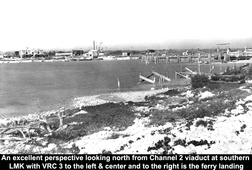
Camp 3
was a large and complex
operation including operating as a mini seaport. It was not a seaport
in the sense of incoming and outgoing ocean traffic, but it serviced
the Sarasota quarterboat, a
huge dredge, several pile drivers, coffer
plate
drivers, barges, several tug boats, a floating concrete plant, a
mosquito control boat, etc. Potable water was brought in by rail tank
cars and pumped into an
elevated tank for gravity supplying. A desal plant was
under construction. It was by far the largest mini port operation other
than Key West which supported the sponge, shrimp, P&O steamship
line not mention the US. Navy. I will estimate
it was 20 to 30 acres in
size allowing for expansion. No actual plans have ever been
found,
which to me is surprising. No management
or
operating plans have been
found to my knowledge. No surveys for the bridge and highway
construction. These almost must be archived someplace, but until they
are found we will try of interpret from often
perspective deceiving aerial photos
if not directly overhead. The hea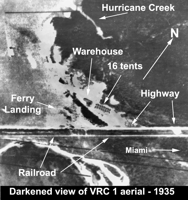 dquarters
for the administration of
the veteran work force was at the Matecumbe Hotel at Islamorada. dquarters
for the administration of
the veteran work force was at the Matecumbe Hotel at Islamorada.
For images I begin with five
photos at the right to portray the camp 3 area of the
past - left clicking on the photos should slightly enlarge them. Other
than the quarry, all construction work was in or out of Camp 3. On a
typical work day there would be the 250 veterans who lived there, from
125 to
150 from Camp
5 and around 50 to 75 technical and operational workers primarily under
the SRD.
The first photo is one half
of an undated panoramic image representing the easter portion of camp
3. The background is the Atlantic Ocean. Closer to us from across the
upper portion is the railroad and just this direction is the highway.
At the center left is a group of 64 cabins which housed from 4 to 8
people per unit. At the center right is the transportation building
with a a few other offices. The other half of the photo has a few more
cabins, an open air storage area of lumber, etc. plus some uncleared
land. To the right of this image would the work area of docks, concrete
plants, fuel storage, etc. I would estimate that the photographer was
facing about east.
The second photo was taken from the Channel 2 bridge approach looking
back at the ferry landing to the right and the eastern part of Camp 3
to center and left. The docks and bridge construction area is seen in
this photo. Again estimating the photographer is facing about north.
The third photo is of the same
U.S.G.S. 1935 aerial survey that I used to show the Windley Key camp 1
living area. For some reason the resolution is not as good here and all
that I can detect is a warehouse and 16 either square tents or cabins.
The negatives of this U.S.G.S. survey are not dated and I attempt
estimating a date for object seen which provide a reasona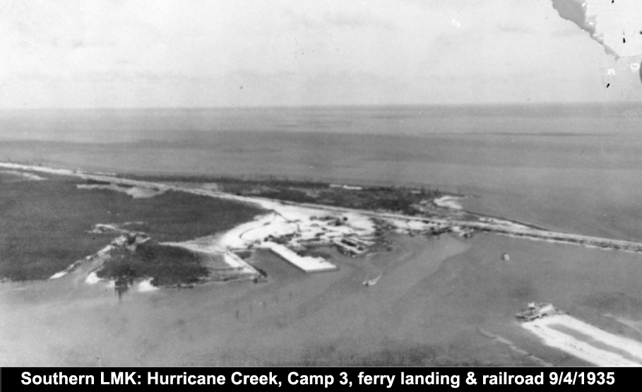 ble
date. We
know that the Windley Key camp was not started until November 7, 1934;
and it was destroyed September 2, 1935; therefore,
the date is within this range. My estimate the third photo is December,
1934 in the early construction stage. ble
date. We
know that the Windley Key camp was not started until November 7, 1934;
and it was destroyed September 2, 1935; therefore,
the date is within this range. My estimate the third photo is December,
1934 in the early construction stage.
The fourth photo shown at the right is from the the
U.S. Coast Guard seaplane that flew
over on an inspection and photo-op during Wednesday, September 4, 1935.
Actually on one flight, possibly this one, it landed and took some
wounded out - Camp 3 was totally isolated when two causeways to its
north was washed out. Even though this image is slightly out of focus,
the entire
end of Lower Matecumbe Key is in view. At the left is Hurricane Creek,
in the center is the remains of Camp 3, to its right is ferry landing,
then the railroad. At the lower right is the SRD quarterboat, Sarasota. To
the left is Miami and to the right Key West. The ferry landing at No
Name Key 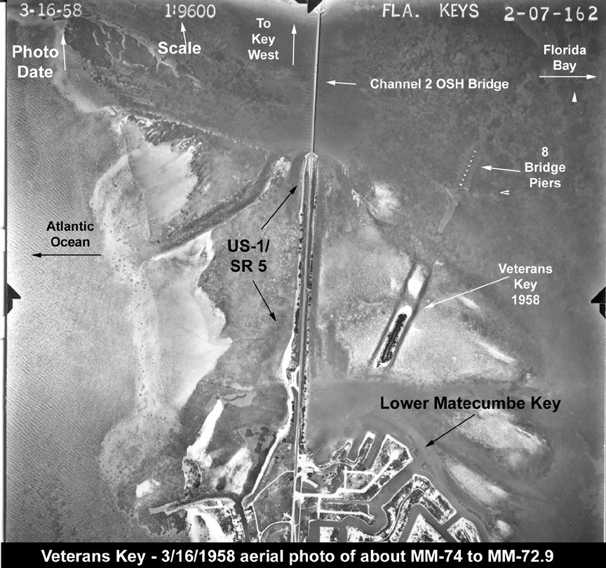 was
not damaged and I am not certain why it was not used for relief efforts. was
not damaged and I am not certain why it was not used for relief efforts.
The fifth photo below right is a March 16, 1958 aerial
which at the
bottom,
shows the area known
as Toll Gate Shores subdivision which had recently been developed. It
was named after the vehicle highway toll gate that was there from 1938
to 1954 and/or the Toll Gate Inn
restaurant and motel that was in
operation on the highway with a long fishing and boating pier
diagonally out
into the water. The Boy Scouts of America's Sea Base Camp is where the
ferry landing, Crosland
Fish Co. and Bradford store were. The left two
closed water inlets were the two used for docking the Camp
3 marine equipment. I feel almost certain that the subdivision
developer dredged
the other canals plus modifying Hurricane Creek.
Recently named Veterans Key which
is the remains of the earthern road approach leading to the surviving
eight
bridge piers are clearly seen.
Channel 2 bridge is top-center.
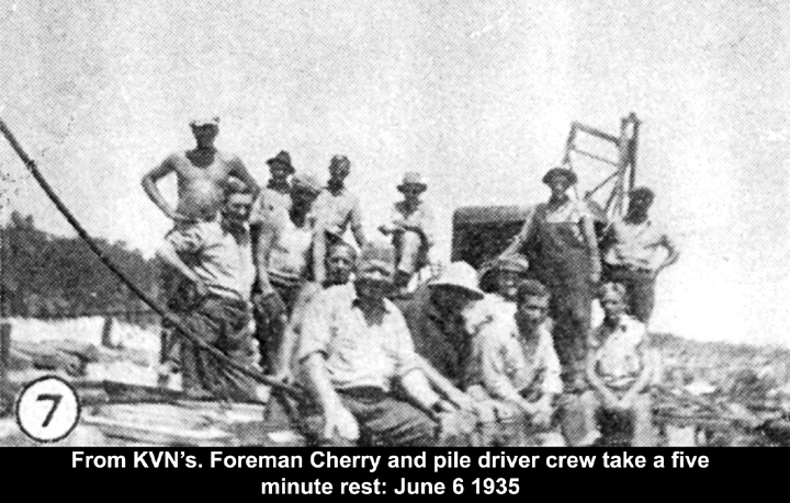
The Key Veteran News (KVN), the
local veterans' produced newspaper, in its June 8th 1935 issue pub
ished a collage of eight photos taken by Lenny Picata. The collage
had a printed description below the group. I scanned and
extracted each as a separate photo and added a caption from their
selection. Remember, photos from
newspapers are half-toned meaning shades
of gray is done with the
density of dots - solid dots black, no dots white paper - in this case
stained
light
brown; therefore of degraded resolution.
Again I will have to do some space
management as I have little text to accompany
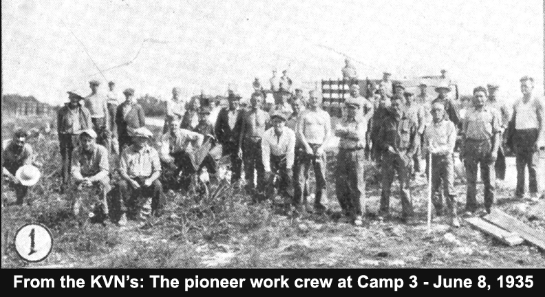
each photo. Photo number one shown at the
right is titled - Pioneers arriving on the site of Camp No. 3. This was
a collage of photos and meant to viewed as such. Please follow the
black numbers in white circles. I will resist making up text just to
fill space. There is a second collage that will further explain the
purpose - to build a concrete arch bridge much as Henry Flagler did for
the railroad. Follow the numbers and some are portrait photos and some
are landscape, so they do not fit nicely together - there is more.
Below left in photo 1 are the work crew
who were the first veteran laborers at Camp 3. The June 1935 date is
the issue date of the KVN's.
  -
-
-
-
-
-
-
-
-
-
 - -
-
- -
-
-
-
-
-
-
-
-
-
-
- -
-  -
-
-
-
-
-
-
-
-
-
-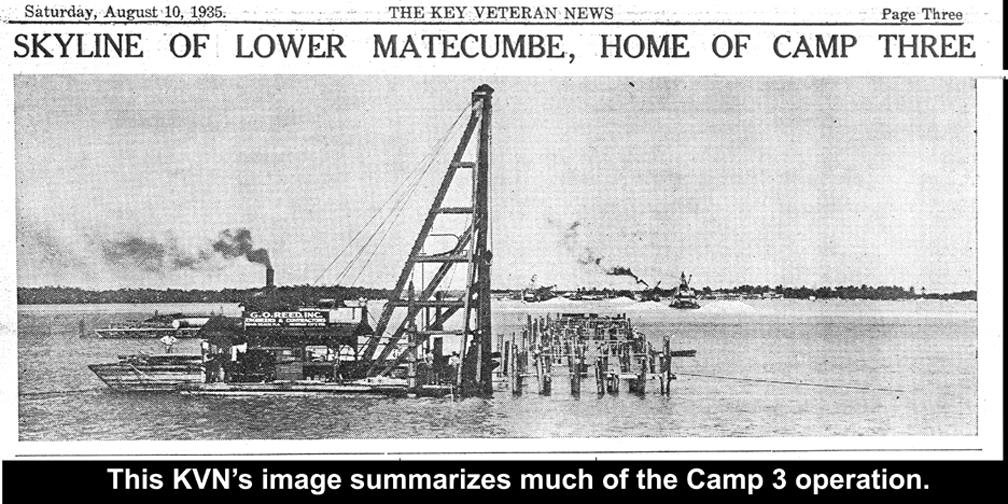
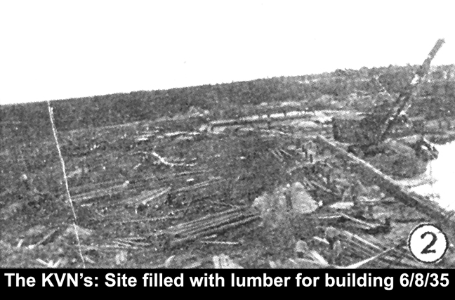
- The skyline image above is
earlier than the August 10, 1935 publication. The pile drivers here are
contract machines and crews (G.O. Reed, Inc.) and were to show progress
in the project. These were probably the three groups that were
completed when the Hurricane hit. It is difficult to see but
considerable dredging has been done to make the eventual earthern
approach to connect the concrete bridge to Lower Matecumbe Key. The
remains of this fill was responsible for Veterans Key coming into
existence - both ends of
the approach were washed out.
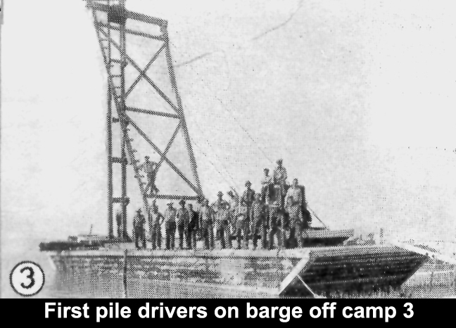
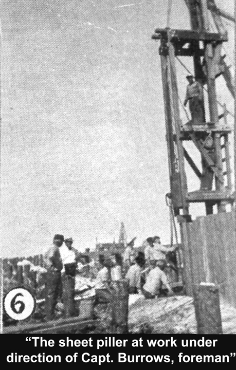
The piles shown in
the above photo were to support the sheet piles for a steel cofferdam.
A cofferdam, aka coffer, is a sealable enclosure which allows work
surrounded by water. In this case steel corrugated coffer piles were
driven into the bottom to form a rectangular form. Another name is a
caisson. Next the steel coffer dams
were sealed, the water pumped down and more piles driven in the center
to anchor the entire pier when completed, then a wooden form built to
contain the concrete and coral block combination . Then the concrete
plant and a combination of derricks anchored and the two (coral blocks
and
concrete) were placed and poured, then allowed to cure. Both outer
casings were removed and reused if serviceable.
The following images are from the
July 13, 1935 issue of the Key
Veteran News. This images are of
technical nature and I ask not to forget the men how labored to make
these photo possible. Unfortunately this issue's
photos are very poor, but hopefully good enough to portray the
construction scenario. Photo number one was too poor to be used;
therefore, I begin with number two: 
The photo at the left (2) with
two hoppers, one for portland cement and the for sand/gravel is the
barge mounted concrete plant. I am not certain how the concrete was
mixed or transported to the cofferdam.
The photo to the right (3) shows the concrete plant with two barge
mounted derricks filling a cofferdam with coral blocks surrounded with
concrete.
-
-
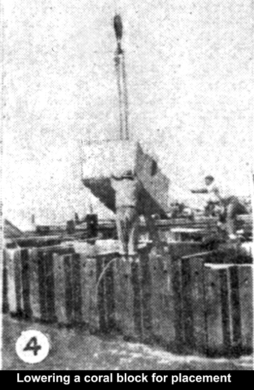 
Number 4
photo
shows a 5-ton coral block from Camp 1 quarry being lowered above an
open cofferdam for placement inside, then surrounded by a concrete
mixture.
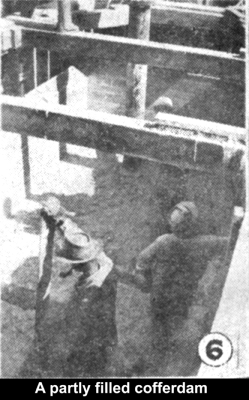
Number 5 photo
shows an empty wooden form after it has been anchored at the bottom
with driven piles and sealed with concrete. This cofferdam is ready to
be filled with coral blocks and concrete.
-
-
-
-
-
-
-
-
The photo to the
left
shows two workers distributing new concrete in layers in preparation
for placing a coral block as a filler; thereby, reducing the amount of
concrete required. I see nothing to connect the layers together.
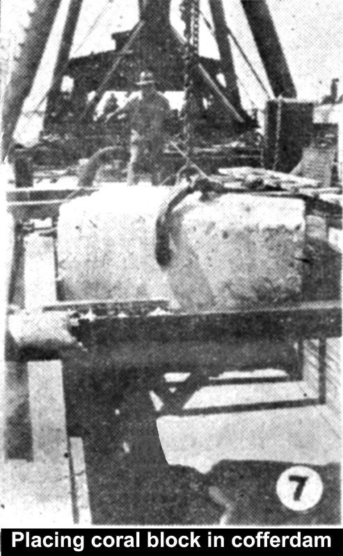
At the right is a coral block being lowered into proper placement
for enclosing with concrete. Note the simple tongs apparatus for
holding the block of coral. This lifting and lowering procedure was a
function of the derrick and a team of riggers. Note the blocks are
being lowered across the pier and each block is 8-feet across.
-
- Below left in photo 8 is
a worker according to the caption "tamping" new concrete. The vertical
pipe is in a number of photos and I am not certain what use it was -
most likely to evacuate water or bring in concrete. Below right in
photo 9 is the wooden form for concrete containment and the sawed off
tops of pilings that have been driven down into the cap rock of the
Channel 2 area. 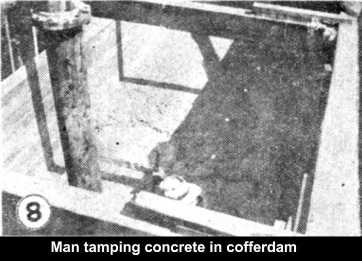
-
-
-
-
-
-
-
-
-
-
-
-
-
-
-
-
|